GIS in Chicagoland
The prevalence of GIS and digital mapping in the Chicago region is nothing new. The footprints of GIS are everywhere. Local government offices were early adopters of mapping technology, using GIS and spatial analysis to maintain or improve their interests. Currently, it is difficult to find a local government office in the region that does not have its own GIS department. If none is present, the offices often use an outside consultant, like MGP Inc., which performs geospatial tasks for them. Regional GIS associations like the Illinois Municipal Arc Users Group exist almost entirely to serve government GIS users in the region and have heavy participation.
While most academic institutions in Chicagoland have modest GIS or Geography programs in terms of relative size, their faculty, students, and research definitely have noteworthy quality and content. Northern Illinois University (DeKalb, IL), University of Illinois at Chicago (Chicago, IL), DePaul University (Chicago, IL), and Elmhurst College (Elmhurst, IL) are just some of many in the region that offer graduate and/or undergraduate degrees with concentrations in GIS along with GIS certificate programs. Other institutions still recognize the importance of GIS and carry it as a primary subject in a variety of classes, such as the University of Chicago (Chicago, IL).
Other Local non-profit organizations use GIS for various purposes that you can likely guess just given their names. The Alliance for the Great Lakes, Archdiocese of Chicago, Chicago Teachers’ Union, Illinois Natural History Survey, Metra, and The Chicago Community Trust, are just a few out of hundreds. Other organizations in Chicagoland promote GIS usage and collaboration among its members like the Illinois GIS Association, Geographic Society of Chicago, and the Chicago GIS Network .
Finally, many recognizable corporations and businesses based in Chicagoland use GIS and spatial analysis to accomplish all sorts of tasks from market research to site placement and from human resources to transportation logistics. McDonald’s, Walgreens, Potbelly’s, and Aon along with scores of others, employ GIS on a daily basis. Chicago is also home to other entities like HERE which is a global leader in providing mapping and location intelligence data.
However, with all this GIS use going on, the Chicago region is not really a stand out. It is more of an example of what has been happening in other metropolitan areas around the United States and around the world. People recognize the power of spatial analysis and GIS. One by-product of this recognition is the hunger for more location-based data. Even though Chicago area GIS users are equal to others in terms of who is using GIS and spatial analysis, Chicago is far ahead of its peers in terms of answering the call for more spatial data.
Approximately three years ago, the city of Chicago committed to an open data initiative that would theoretically inform policy and improve services by putting municipal data in the hands of anyone who wanted it. Today the city of Chicago’s data portal provides a huge number of records to the general public. A large percentage of the data is location-based. The site has been a major success and influenced Cook County, which includes the City of Chicago, to release their data in the same manner.
This open data allowed researchers, concerned citizens, application developers, and any general map lover to download any or all location-based data from these portals and begin to analyze and display phenomena happening in the metropolitan area. Open City is just one group in the region that creates applications with open data to improve transparency in operations. Many of these applications involve spatial data and mapping applications.
Clear Streets is a good example of these applications and a favorite among Chicago residents. During or after a snow event, Clear Streets displays on a map which streets have been cleared of snow along with a time stamp of when it occurred. The City of Chicago’s snow plow tracker website conveys real time information on where snow plows are in the city. However, users do not know whether their street has been plowed or not. That is where Clear Streets steps in and gives an accurate depiction of what parts of the city have been plowed (at least once) using the data feed from the city’s plow tracker site.
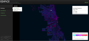
Another mapping application, Is There Sewage in the Chicago River?, tracks sewage dumps into the Chicago River and plots them on a map. Chicago Bike Crash Reports pinpoints every location in Chicago where a bike accident occurred and had a police report filed along with it. One of the more attractive applications built with this publicly available data is Edifice which tracks the city’s built environment.
The list of datasets available is staggering. This initiative in the Chicago area has led to similar data distribution efforts in the region and in other cities like New York, Boston, and Los Angeles. Using this location based data just from a visualization standpoint gives a greater understanding to the geography of the region and how different processes may work together to form the landscape.
GIS use is at the forefront of this initiative because it is the perfect marriage between maps and data. From here, spatial analytics and statistical methods can provide evidence to whether urban planning initiatives are working, crime is being reduced, or potholes are getting filled. These questions may seem simple to answer but become far too complex to handle in any other fashion when the scale is increased to encompass such a large area.
Other sites to note:
- Get a Flu Shot
- Chicago Immunization Events
- Safe Havens for CPS Students
- Transit Future
- 2nd City Zoning
- Vacant and Abandoned Building Finder
- Chicago Public School Tiers
—Todd J. Schuble
Manager of GIS Research/Senior Lecturer
University of Chicago