The AAG is pleased to announce the selection of seven Honorees who will receive the 2017 AAG Honors in one of four categories. Recipients to be honored at an annual awards luncheon during the AAG Annual Meeting are:
- Patrick Bartlein, University of Oregon, AAG Distinguished Scholarship Honors
- Ruth Fincher, University of Melbourne, AAG Lifetime Achievement Honors
- Kent Mathewson, Louisiana State University, AAG Ronald F. Abler Distinguished Service Honors
- Michael Pretes, University of North Alabama, AAG Distinguished Teaching Honors
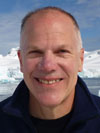
- David Robinson, Rutgers University, AAG Lifetime Achievement Honors
- Michael Storper, University of California Los Angeles, AAG Distinguished Scholarship Honors
- Julie Winkler, Michigan State University, AAG Ronald F. Abler Distinguished Service Honors
AAG Honors are the highest awards offered by the Association of American Geographers. They are offered annually to recognize outstanding accomplishments by members in research & scholarship, teaching, education, service to the discipline, public service outside academe and for lifetime achievement. Although the AAG and its specialty groups make other important awards (see Grants and Awards), AAG Honors remains among the most prestigious awards in American geography and have been awarded since 1951 (complete list).
Nominations are invited from individual AAG members, specialty groups, affinity groups, departments, and other interested parties. Currently, honors are awarded in several categories, including Distinguished Teaching Honors, Gilbert F. White Distinguished Public Service Honors, Ronald F. Abler Distinguished Service Honors, Gilbert Grosvenor Honors for Geographic Education, Distinguished Scholarship Honors, and Lifetime Achievement Honors.
All AAG awards will be presented at the upcoming AAG Annual Meeting in Boston, during a special awards luncheon on Sunday, April 9, 2017.
About the Honorees
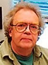 Patrick Bartlein – The Distinguished Scholarship Honors is presented to Patrick Bartlein for his fundamental contributions to fields across and beyond physical geography, including paleo-climate, biogeography, geomorphology, meteorology, water resources, hydrology, statistics, spatial analysis, geology, ecology and archaeology. He has been integral to major international and interdisciplinary collaborations, such as the Cooperative Holocene Mapping Project (COHMAP), the Paleoclimate Modeling Intercomparison Projects (PMJP) and national and international climate change assessments. Bart (as he prefers to be called) has 200-plus publications that have been cited some I8,000 times, touching on topics ranging from water balance modeling to Holocene vegetation and wildfire interactions to the potential effects of future climate change on species distributions. A visionary scholar with a rare ability to think across multiple temporal and spatial scales, Bart bas illuminated climatological phenomena from decades to billions of years in time and from meters to continents in space. The AAG is proud to honor him with its Distinguished Scholarship Honors.
 Ruth Fincher – The Lifetime Achievement Honors is presented to Ruth Fincher for her contributions to geographical research, teaching, and service. Her dual focus on the lived experiences of disadvantaged populations and the political-economic structures within which those populations struggle has been a core part of her work throughout her career. So too has a focus on local issues, from neighborhood redevelopment to immigration and identity to rising sea levels. Beyond Fincher’s policy-relevant research, she has served on multiple advisory boards and committees at the national and international levels; has been elected Vice-President of the International Geographical Union; and has been honored as a Member of the Order of Australia. Her advocacy for geography within her university and on an international level has strengthened the health of the discipline beyond her outstanding research and teaching.
 Kent Mathewson – The Ronald F. Abler Distinguished Service Honors is presented to Kent Mathewson for his tireless and frequently ‘ behind-the-scenes ‘ advocacy for geographic scholarship and historiography. He is particularly appreciated for his tireless work “recognizing and celebrating the work of book authors” through his long-time work as Book Review editor and most recently as Editor-in-Chief for The AAG Review of Books. His unwavering support for book authors is described as a contribution that is “essential to the intellectual vigor of our discipline.”
 Michael Pretes – The 2017 Distinguished Teaching Honors is presented to Michael Pretes for his contributions to geographic education both within and outside the classroom. He has been a faculty member at the University of North Alabama since 2006 where he is an exemplary teacher-scholar. His students and colleagues extoll his passion for geography and his ability to instill a love and respect for geography in his students. In 2013 he was awarded with the university’s most distinguished award, the Phi Kappa Phi Eleanor Gaunder Award for excellence in undergraduate education. In addition, in 2015 he received the Southeast Geographers Excellence in Teaching Award. He held teaching and research positions at several institutions in the United States, and abroad. In addition to his work with undergraduate and graduate students he has reached out to students in secondary classrooms and members of communities where he lived and worked. Pretes is highly active in geographic education through various organizations such as the American Association of Geographers, the Southeast Division of the AAG, the Association of Pacific Coast Geographers, the Royal Geographical Society, the Arctic Institute of North America and the American Association of Hispanics in Higher Education.
 David Robinson – The AAG Life Achievement Honors is presented to David Robinson because he is a multi-dimensional geographer who has achieved extraordinary success and impact in many domains simultaneously. As a researcher, he is a leading figure in the fields of climate science and climatology and one the world’s foremost experts on global snow cover. As New Jersey State Climatologist for the past 25 years, he is among the most publicly prominent geographers in the New York-New Jersey region, granting hundreds of media interviews each year while also overseeing a publicly accessible statewide climate and weather data network. As a long-serving department chair at Rutgers, Robinson fostered a culture of success that combined scholarly achievement with mentorship, collegiality and mutual respect among all members of the department.
 Michael Storper – The Distinguished Scholarship Honors is presented to Michael Storper for his outstanding record of scholarly achievement and innovative contributions to the fields of global economic development and the geography of urban and regional systems. He has held academic positions at highly reputable institutions in both the United States and Europe. His exceptional research has led to widely cited and highly influential scholarly publications and foundational contributions to economic and urban geography and related disciplines. The depth and quality of his work has put him in a category of scholarship that is truly deserving of this prestigious AAG award.
 Julie Winkler – The Ron Abler Distinguished Service Honors is presented to Julie Winkler in recognition of her sustained and committed work to the AAG, the discipline of geography, her department, and her state and community. She has served as an officer in several national and international professional organizations; on the editorial boards of numerous high ranking journals (17 on the board of the Annals of the AAG); and has brought her insights to bear in guiding several departments through programmatic reviews. Her career has been marked by those things held as noteworthy by Ron Abler – a desire to sustain the breadth and vitality of geography, support of faculty in their careers, and a commitment to move the field in a direction that is marked by integrative approaches. She has done this exceptional service without sacrificing her contribution to research and teaching.
 Nina Feldman, a former intern with AAG and the Geography and Map Division of the Library of Congress, shares why she chose a career in GIS and Geography in a very poignant guest blog post for
  Cassidento brings a wealth of editorial expertise and experience to the AAG publications. She has worked previously with major scholarly publishing houses, and for several years with the AAG on its journals, serving as managing editor of three of its flagship journals, including the Annals of the American Association of Geographers, the AAG Review of Books, and GeoHumanities. Jennifer also provided outstanding support and played a central role in the production of the forthcoming 15-volume AAG International Encyclopedia of Geography: People, the Earth, Environment, and Technology, which will be published in March of 2017.
 The AAG receives numerous requests for data related to geography and geographers. Often such requests come from members who are doing research on the discipline, or who are interested in knowing, for example, the proportion of women who hold the rank of associate professor or the average value of a graduate student assistantship.
 The AAG is participating in an international effort to design and develop a geography assessment based on the successful model used by the International Association for the Evaluation of Educational Achievement (IEA) for the Trends in International Mathematics and Science Study (TIMSS). Major collaborating organizations include the International Geographical Union Commission on Geographical Education (IGU-CGE) and the IEA/TIMSS. The initial funding for this project is being provided by the Geography Education National Implementation Project and the U.S. National Center for Research in Geography Education.
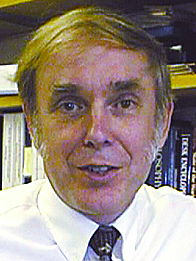 Roger M. Downs, professor of geography at Pennsylvania State University, will receive the 2017 AAG Presidential Achievement Award, which honors individuals for their long-term, major contributions to the discipline. Past President Sarah Witham Bednarz will confer the award during the close of her Past President’s Address at the AAG annual meeting in Boston. She remarked, “Downs is a scholar, excellent administrator, and guiding light for geographers interested in teaching and learning.”