The Geography of Despair (or All These Rubber Bullets)
Aretina R. Hamilton
This article was originally published on Medium. Follow Dr. Hamilton on Twitter at @BlackGeographer.
As a scholar, I entered the world of academia as a planner. I examined urban planning and the devolution of American cities — and then I discovered Geography. The original scene of the crime. This original technology was used to cut up the world into pieces and to fulfill manifest destinies. When non-Geographers think about Geography, they imagine GPS maps, landscapes, physical terrain, and valleys. They don’t think of culture, people, conflict, contestation, imperialism, or exploitation. In the same way, geographical thinking frequently ignores how geographies enact violence, create spaces of belonging, reproduce systematic equalities, and codify race. Yet for Black People, geography operates across multiple sites and multiple planes, and it is all-encompassing, frequently defining the outcomes of our lives.
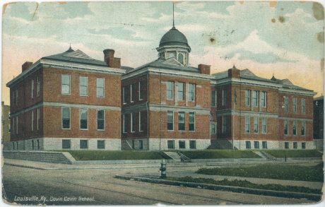
My first site of geographic containment occurred within the walls of my mother’s uterus. It was a site of warmth, love, and nourishment. Even before I sprang into the world, I could feel the yearning for me and the love of my parents as they spoke to me. As a Black child growing up in Louisville, Kentucky in the 1980s, I began to understand that my geographies were filled with visceral meanings and assumptions. At my elementary school, I attended one of the most racially and socioeconomically diverse schools in the city. We were a fulfillment of the dream. However, as I grew older and reflected back on those times, I remember how the Black kids who lived in Southwick, Parkhill, and the West End were disproportionately called out for behavioral or socio-emotional issues. They lived in spaces that lie along the margins of the map, sites on “the other side of the tracks,” and there was a definite difference in how they were treated. At that age, we never discussed where we came from, but we knew that geography had a dramatic impact on where we might end.
Gavin H. Cochran Elementary School, Louisville, Kentucky
In March, when one of my best friends called and told me that a Black woman was murdered by police in Louisville, I sighed. Breonna Taylor, a 26-year-old African-American emergency room technician, was killed by police who used a battering ram to crash into her apartment and kill her. I was so sick of hearing stories of Black Death, but this one happened in my hometown. For months and years before, I had heard stories of shootings in the city but had tried to block it out — if only temporarily. I think I had become numb or was trying to isolate the pain. I hadn’t lived in Louisville in over 20 years, but I remembered the racial politics and understood that the history of racial residential segregation, gerrymandering, white flight, and educational disparities had set the stage for this event. The police who murdered Breonna and David McAtee had a particular understanding of the geography and understood that these geographies and the people that lived in them didn’t matter. They were considered disposable and irrelevant.
Share
News
The “Nation’s Report Card” on Geography Reveals a World of Opportunities
Periodically since 1994, the National Assessment of Educational Progress (NAEP) has released its “report card” on geography education in America, providing a snapshot of student achievement. The most recent assessment was conducted in 2018 with a nationally representative sample of nearly 13,000 8th grade students.
NAEP assesses geography achievement in three content domains:
Space and place questions measure students’ knowledge related to particular places on Earth, spatial patterns observed on Earth’s surface, and the physical and human processes that shape spatial patterns.
Environment and society questions measure students’ knowledge of how people depend upon, adapt to, are affected by, and modify their natural environment.
Spatial dynamics and connections questions measure students’ ability to understand geography as it relates to spatial variations and the connections among people and places.
Within each content domain, questions test student cognition in three dimensions: knowing (what is it? where is it?); understanding (why is it there? how did it get there? what is its significance?); and applying (how can geographic knowledge and understanding solve problems?).
There has been no change in the 8th-grade geography average score since 1994, which means three out of four 8th graders still perform below “NAEP Proficient” (defined as competency over challenging subject matter);
There was a three-point decline in the geography average score since 2014;
2018 scores are lower in the “Space and Place” and “Environment and Society” content areas compared to 2014; students also scored lower in “Environment and Society” compared to all previous assessments in 2014, 2010, 2001, and 1994.
Whenever NAEP Report Cards signal setbacks in student achievement, it is common to see an uptick of press lamenting the latest round of bad news about how much young people don’t know. Yet this media coverage does not convey the many opportunities NAEP assessments offer to stakeholders to gain valuable perspective on the educational context in which students, teachers, and schools pursue knowledge and instruction about our world. Geographers owe it to our discipline to dig deeper into these data to learn how geography education is or is not working for American students—and which students are missing out the most. Investing in this type of research now can not only influence the educational outcome for the next generation of geographers, it can also afford important insight into the practice and advancement of our discipline.
A Rich Source of Data for Research, Public Advocacy, and Equity in Education
NAEP reports do not include interpretations or explanations of achievement scores for different groups, nor do they make value judgments on the significance of the subject matter assessed. It’s up to education researchers to search for those clues in the data, and therein lies an important opportunity for geographers: to use NAEP data and reports in ways that support the discipline. Here are just a few examples.
Improve public understanding and perceptions of geography.
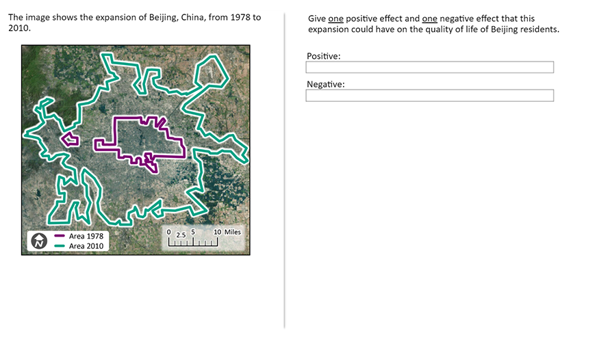
Geographers can use NAEP to counter misconceptions about what geography education entails by showing what it means to be proficient in geography. NAEP releases sample test questions to help the public understand how knowledge, understanding, and application in each content area are measured. Figure 1 shows a released “Spatial Dynamics & Connections” question that only 8 percent of eighth graders correctly answered. This is an opportunity for geographers to make a case for geography education by explaining how geography teaches conceptual knowledge and offers tools that can help young people understand and act on important and complex real-world issues such as urban growth and urbanization.
Figure 1: Sample question for the geography subject NAEP 2018 assessment.
Address issues of equity, access, and justice in education.
Since the first geography assessment in 1994, NAEP has repeatedly reported stark achievement gaps. When achievement scores are examined by race and ethnicity, we see that scores for Hispanic and Black students have consistently fallen near “NAEP Basic” (defined as partial mastery of prerequisite knowledge and skills that are fundamental for proficient work). Over the same quarter century, disciplinary data show that geography college majors and professionals have remained disproportionately white and male.
Geographers have a robust record of analyzing relationships among race, ethnicity, and place, and there have been many national initiatives to enhance disciplinary diversity. NAEP offers geographers a chance to extend these efforts by conducting K-12 educational research utilizing NAEP’s deep contextual datasets to identify factors that appear to explain achievement gaps. This information could then be used to inform educational interventions that address achievement disparities.
Additionally, geographers can use NAEP data to search for clues about subject matter and instructional strategies that students of color perceive to be interesting, useful, and culturally relevant. All of this can open up new frontiers of research collaborations involving teams of geographers, psychometricians, educational assessment experts, and curriculum theorists.
Promote the values and uses of geography
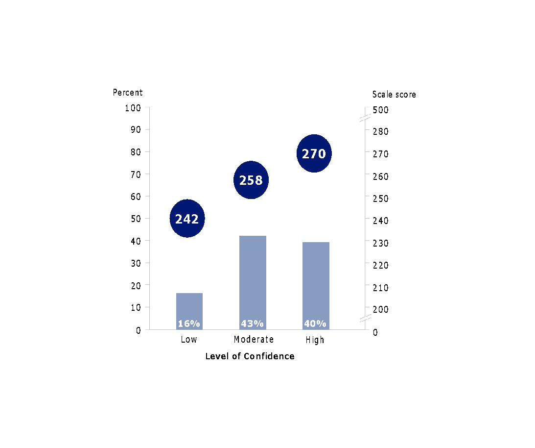
An important finding from diving deeper into NAEP data is that more confident learners perform better on the geography assessment (see Figure 2). How do we make learners more confident, you ask? Research using data from the Programme for International Student Assessment (PISA)1 suggests one of the most effective ways of increasing students’ confidence to do science is by conveying the applications and relevance of science.
Each of us, being geographers, are well-positioned to act on this information. For example, you can participate in AAG’s GeoMentors program, visit schools to discuss career opportunities in geography, share examples of how geographers apply their expertise in the context of work and civic life, and contribute to teacher professional development and curriculum initiatives.
AAG encourages our members to review the 2018 NAEP geography report and use the findings to renew efforts to improve the quality of geography education in the nation’s schools. A great tool for getting started is the NAEP Data Explorer.
The National Center for Research in Geography Education is also organizing a research network for geographers interested in pursuing research using NAEP data. The goal of this network is to plan a long-term research strategy utilizing NAEP geography reports and datasets. This is an opportunity for geographers to apply spatial methods for analyzing large quantitative datasets, potentially resulting in new geographic insights about education. AAG invites interested individuals to join this network by completing this form.
Matt Rosenberg to Receive AAG Media Achievement Award
The 2016 AAG Media Achievement Award is presented to Matt Rosenberg in recognition of his success in promoting greater understanding of geography through his work in the web and in social media. He has developed his website geography.about.com into one of the most popular in the internet devoted exclusively to geography. Through this work as well as his books and outreach activities, Rosenberg has become an outstanding spokesperson for geography, geographical literacy and geography education.
Matt Rosenberg, About.com
Matt Rosenberg is awarded the 2016 Association of American Geographers Media Achievement Award in recognition of his success in promoting greater understanding of geography through web and social media, as well as through his other publications and work. Over a period of 18 years, Matt’s hard work and enthusiasm built one of the most popular sites in the internet devoted exclusively to geography.
In addition to his site at geography.about.com, Matt has published two books about geography, including The Handy Geography Answer Book. Matt has been featured on PBS and NPR and has conducted many interviews about geographical topics for television, radio, and newspapers. In October 2006, Matt was awarded the Excellence in Media Award from the National Council for Geographic Education for his contributions over the years to the discipline of geography and to geography education.
Mr. Rosenberg holds a master’s degree in geography from California State University, Northridge and a bachelor’s in geography from the University of California, Davis. His master’s thesis was natural hazards in Ventura County, California; a topic close to Matt’s other professional work as a disaster manager for the American Red Cross. Matt has served on more than two dozen major disaster relief operations around the United States. He has traveled widely across North America, Europe, Asia, Africa, and the Middle East and is an active member of the Association of American Geographers and the National Council for Geographic Education.
For his exceptional contributions to geography in the web, for his engagement with media, and his contributions to geography education and the promotion of greater public understanding of geography, we honor Matt Rosenberg.
Share
Annual Meeting
A Taste of New Deal Alphabet Soup in San Francisco
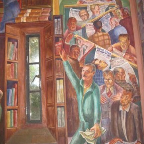
One of several controversial panels at Coit Tower. A library scene painted by Bernard Zakheim, in which patron (fellow muralist John Langley Howard) pulls a copy of Das Kapital from the shelf. Photo: Shaina Potts for the Living New Deal. Mural: Bernard Zakheim
Coming to San Francisco for the annual meeting next spring will mean inevitably traversing a landscape transformed by the New Deal. For those landing at the San Francisco or Oakland Airports, The Works Progress Administration (WPA), Public Works Administration (PWA), and State Emergency Relief Administration (SERA) all had a hand in their growth into major airports. Crossing over the majestic western span of the Bay Bridge is to rely on the New Deal as well. In 1936 when it was completed at the hands of the WPA, the bridge was the longest suspension bridge in the country. From the bridge, many visitors quickly pick out one of the city’s most visible landmarks, Coit Tower, where the entire interior is covered in New Deal frescos. With funds from the Public Works of Art Project (PWAP), the New Deal’s first public arts program, twenty-six artists spent six months in 1934 creating murals of depression era life and the state’s history. The murals were carefully restored last year and are once again on view to the public as a monument not just to California but a historical moment when the federal government invested directly in the arts, infrastructure and its poorest citizens.
Pieces of San Francisco’s history, like that of Coit Tower, are relatively well known. But the extent of the structural and aesthetic improvements made to the city are just now being recovered by a team of researchers and volunteers at the Living New Deal project. Founded and directed by Berkeley Geographers Richard Walker and Gray Brechin (a longer history of the project is available on our website), the Living New Deal works to rediscover, catalog and map the sites of New Deal art and infrastructure. To many people’s surprise, there are no complete records of New Deal programs; this in part because of their emphasis on ending the Depression as quickly as possible, and in part because of long standing efforts to obscure the New Deal’s success in doing just that. Given the enormity of its scope, over the last decade the Living New Deal has grown into a national collaboration of geographers, researchers from disciplines ranging from art history to economics, students, many amateur historians and untold numbers of volunteers submitting information on what the “alphabet soup” of programs created in their regions. In the same spirit of serving the public good that defined the original New Deal, our group works to make all of the information gathered for our database and map freely available via the web, publications and frequent presentations around the country.
The Living New Deal’s origins in the Bay Area are reflected in the density of New Deal sites already uncovered in and around San Francisco. Those first years of research revealed that no corner of the city was left untouched by WPA, PWA, CWA, CCC or one of the other agencies. As shown on the project’s map, the city is literally dotted with parks, playgrounds, schools and public buildings, street and sewer improvements, murals, sculptures, and other works of art. Neighborhoods famous for other reasons turn up New Deal touches everywhere. A walk through the Castro includes sidewalks still stamped with WPA logos. Chinatown’s St. Marys square is home to a 14-foot tall statue of Sun Yat-Sen by the renowned sculptor Beniamino Bufano, paid for by the Federal Arts Project (FAP). Golden Gate Park is chock full of New Deal improvements that endless hippies, yuppies, and tourists have made use of for nearly eight decades without ever likely considering their origins. Federal funds flowed far beyond just the major cities however, even to Republican led communities like Berkeley (yes, it was a different place in the 1930s), where civic structures like the high school and post office are adorned with art extolling the public value of knowledge and beauty. Just slightly further afield are trails and open spaces made possible by the work of the Civilian Conservation Core (CCC), meant to provide even the most destitute Americans access to the therapeutic dimensions of the “great outdoors.” Of course many of those spaces are still readily accessible to us today. The list of New Deal sites that we take advantage of in the 21st century goes on and on, and grows with every passing week of new discoveries.
While the Living New Deal works to reveal and promote the legacy of work in the name of the public good, the archive and map make apparent that this legacy is in no way free of the problematic politics and mainstream thought of the time from which it emerged. From environmental destruction (note how much “reclaimed” land the airport occupies), to the racist representations and exclusions of indigenous peoples in art celebrating California’s colonial history, to the complicated first “progressive” efforts at public housing (coupled with policies that underwrote the mass suburbanization of whites), the Bay Area contains it all.
In juxtaposition to the relics we find abhorrent in the present, the city also contains projects so radical that they have been raising the ire of civic leaders and the “business community,” for decades; probably none more so than the murals at the Rincon Annex. Created by Russian born artist Anton Refregier, who “wanted to paint the past, not as a romantic backdrop, but as part of the living present, a present shaped by the trauma of depression, strikes, and impending war” (Brechin, 2013), the murals adorn the interior of a beautiful post-office building. The works themselves, however, depict a much more violent history underlying San Francisco’s history, beginning with Sir Francis Drake holding a bloodied sword (his hand infamously reappears emerging from a Nazi flag in a later panel, connecting the original conquest to the rise of Fascism), the murals continue on to show a much “truer” depiction of the Mission system, the beating of Chinese during anti-immigrant riots, the murder of striking workers, and the general hardship that befell many of San Francisco’s pre-war inhabitants. Despite many efforts to stop the murals from being produced in the first place and censorship, they are still on display at the building and open to the public—just a few blocks from the Ferry Building.
For those who will be at the conference, several current and former team members from the project will be on hand and always excited to discuss the New Deal. For those who would like to explore New Deal sites on their own, this is San Francisco, so there is of course “an app for that.” Local public media network KQED worked with the Living New Deal and California Historical Society to create an iPhone and Android app called “Let’s Get Lost,” which features interactive tours of both Coit Tower and Rincon Annex Murals. Or, for the adventurous geographers looking to get out and explore, an actual print map of a self-guided tour of New Deal sites in San Francisco is available.
Geographers who won’t be attending the meeting are still able to explore the legacies of the New Deal in their own regions via the project’s website and interactive map. The Living New Deal has just begun to scratch the surface of what was created by the alphabet soup of federal projects, and strongly encourages interested persons with knowledge of unlisted or incomplete entries for their area to be in touch! Whether in the Bay, another town, or the vast rural and wilderness spaces of the US, the Living New Deal hopes our project will encourage our fellow geographers to look for clues to how the New Deal continues to shape not just the history of the country but the places we inhabit every day.
Alex Tarr is the former project manager at the Living New Deal project and currently the Andrew W. Mellon Postdoctoral Fellow in Spatial Humanities at the Rice University Humanities Research Center. He received his PhD in geography from the University of California, Berkeley in 2015. A more complete list of the many geographers who have contributed to the Living New Deal is available on the website.
Share
Post
Piash Debnath Interns at AAG for Fall Semester
Piash Debnath is a senior at George Mason University double majoring in geography and environmental and sustainabilities studies. He’s currently the geography department’s first and only learning assistant (LA). As an LA, he co-teaches an undergraduate geography class giving students exposure to and better understanding of the discipline allowing them to possibly pursue a minor or major. After graduating, he plans to pursue a masters in geographic and cartographic sciences and a graduate certificate in environmental GIS and biodiversity conservation. He hopes to work for a non-profit that utilizes GIS technology in environmental issues. Currently, he’s a member of Gamma Theta Upsilon and the president of the Bengali Patriots Association. Born and raised in Bangladesh, he wants to be able to use his skills to create maps to help protect the environment.
In his spare time he enjoys playing tennis, volunteering at Novant Prince William hospital and exploring the wilderness.
Share
Post
Old Name Officially Returns to Nation’s Highest Peak
The story of America is told by the names on the land. When you hear names like Kentucky and Kennesaw, Klamath and Kodiak, your mind immediately starts to turn over all manner of associated thoughts of what you may have experienced or learned or even what you may imagine about that place. Geographic names often serve as a mental index and guide to help organize our knowledge of American geography and history.
Most of the time the names of places seem quite mundane because they are so basic in our everyday lives. They are invisible, unremarkable elements of the way we think and communicate. Yet, to borrow a phrase from Sir Francis Bacon*, names carry “much impression and enchantment.” When people disagree about the right name of a place, then the importance of geographic names becomes clearly evident.
Secretary of the Interior Sally Jewell has announced that the highest mountain in the United States and North America, formerly known as Mount McKinley, will now be officially designated by the name Denali in all federal records.
“This name change recognizes the sacred status of Denali to many Alaska Natives,” Secretary Jewell said. “The name Denali has been official for use by the State of Alaska since 1975, but even more importantly, the mountain has been known as Denali for generations. With our own sense of reverence for this place, we are officially renaming the mountain Denali in recognition of the traditions of Alaska Natives and the strong support of the people of Alaska.”
Secretary Jewell issued a Secretarial Order to make the name Denali official in accordance with her authority under the 1947 federal law that provides for the standardization of geographic names through the U.S Board on Geographic Names. Her action was heartily endorsed by President Obama who was participating in a meeting of the international Arctic Council in Anchorage.
Share
Register for Free
Create an account to get free access to exclusive AAG content.
AAG Members get exclusive access to publications, prominent journals, unique advocacy, grant, scholarship and professional opportunities with access to industry focus communities, and event discounts, including our annual meeting.
Some content may only be accessible if you belong to specific Specialty or Affinity Groups. You can still update your membership below. You will need to go through the Join flow, but you do not need to repurchase your membership unless it is expired or about to expire.
To provide the best experiences, we use technologies like cookies to store and/or access device information. Consenting to these technologies will allow us to process data such as browsing behavior or unique IDs on this site. Not consenting or withdrawing consent, may adversely affect certain features and functions.
Functional
Always active
The technical storage or access is strictly necessary for the legitimate purpose of enabling the use of a specific service explicitly requested by the subscriber or user, or for the sole purpose of carrying out the transmission of a communication over an electronic communications network.
Preferences
The technical storage or access is necessary for the legitimate purpose of storing preferences that are not requested by the subscriber or user.
Statistics
The technical storage or access that is used exclusively for statistical purposes.The technical storage or access that is used exclusively for anonymous statistical purposes. Without a subpoena, voluntary compliance on the part of your Internet Service Provider, or additional records from a third party, information stored or retrieved for this purpose alone cannot usually be used to identify you.
Marketing
The technical storage or access is required to create user profiles to send advertising, or to track the user on a website or across several websites for similar marketing purposes.