Taking Steps to Create a Welcoming Discipline for ALL Geographers: A New Resource for Indigenous Students
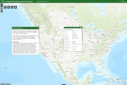
 The AAG is pleased to announce the release of a new interactive web map of colleges and universities that offer both Geography Programs and Indigenous Studies Programs. Developed in consultation with members of the AAG’s Indigenous Peoples Specialty Group (IPSG), the map serves to help Indigenous students find safe places to pursue a Geography degree. In this case safe places refer to colleges and universities that have an active Indigenous Studies program, cultural center, or other active organization that can act as a support system for Indigenous students to keep them connected to their traditional communities and provide mentorship to help them achieve their academic goals. In many cases, this also includes colleges and universities that are geographically accessible to students, meaning the school is a commutable distance from their homes or within their home state for the purposes of in-state tuition.
There is a strong record of the application of geography, and specifically GIS, to address the needs of Tribal Governments and associated communities. Tracking land ownership records for resource management and land claims,[1],[2] assisting Tribal Governments with improving medical services, transportation, and economic development, and the preservation of cultural and natural resources[3],[4] represent a few of the ways spatial techniques and GIS have assisted indigenous communities. Coupled with the expectation that the GIS industry will grow by 10% each year through 2023[5], encouraging Indigenous students to pursue Geography could not only present opportunities in a growing field but provide tools and skills to better serve the needs of their own communities.
AAG Membership Data
Since 1981, the AAG has seen a gradual increase in the number of minorities within its membership. In the early 2000s there was a dramatic increase in the number of members who identify as Asian, African American, and Hispanic, however, the number of members who identify as Native Alaskan, Native American, or Pacific Islander has not followed that trend (Graph 1).[6] This suggests that Indigenous people have not been welcomed and included in Geography to the same extent as other underrepresented groups, a concern of the AAG as the Association is dedicated to “promoting inclusion, equity, and social justice across the entire discipline.”[7]
![Graph 1: AAG Minority Membership since 1981.[6]](https://www.aag.org/wp-content/uploads/2021/11/AAG-minority-membership-640x332-1-300x156.png)
The Interactive WebMap
To address the need for greater Native American, Native Alaskan, and Pacific Islander representation in the AAG, the AAG has developed a database and interactive webmap to help students find schools suited to their needs. The database and interactive webmap was built by cross-referencing the American Indian Higher Education Consortium’s (AIHEC) list of Tribal Colleges,[8] the Guide to Native American Studies Programs in the U.S. and Canada,[9] and the AAG’s Guide to Geography Programs in the Americas[10] to identify schools in the US and Canada that qualify as a safe place. The academic catalog for each school was reviewed to determine if they offered both Geography Programs and Indigenous Studies Programs. Those that did were then added to the database along with information about the level of degrees offered in both fields as well as any cultural centers, administrative departments, or student organizations that would also be beneficial, as well as direct links to those websites.
Some of the identified colleges and universities do not offer degrees in both fields but were still included in the database because they have another structure in place that would also fulfill that need. For example few Tribal Colleges offer degrees in geography but do offer geography courses and, as institutions run by and for their communities, support structures for students are already available. Likewise, a couple of the schools included in this database do not offer an Indigenous Studies degree, but support research centers, cultural centers, or other partnerships with community organizations that would also fulfill that need. The result is a database of 185 colleges and universities across the United States and Canada.
Once the database was completed, a corresponding webmap was made as a method of searching the database spatially and includes filters to help students narrow down potential schools. The map includes two query tools that allow the user to select schools based on the degree they are interested in pursuing. One of these filters selects programs by the level of Geography degrees and the other sorts by the level of Indigenous Studies degrees. The application also includes a filter tool that allows the user to select schools by country (United States or Canada), State or Province, or highlight only Tribal Colleges.
For more information please contact:
Jolene Keen, Research Associate, American Association of Geographers
[1] Barcus, Holly R., and Laura J. Smith. “Facilitating Native Land Reacquisition in the Rural USA through Collaborative Research and Geographic Information Systems.” Geographical Research 54, no. 2 (12, 2015): 118-28. doi:10.1111/1745-5871.12167.
[2] Chapin, Mac, Zachary Lamb, and Bill Threlkeld. “Mapping Indigenous Lands.” Annual Review of Anthropology 34, no. 1 (10 2005): 619-38. doi:10.1146/annurev.anthro.34.081804.120429.
[3] Horn, Brady P., Gary N. Barragan, Chis Fore, and Caroline A. Bonham. “A Cost Comparison of Travel Models and Behavioural Telemedicine for Rural, Native American Populations in New Mexico.” Journal of Telemedicine and Telecare 22, no. 1 (05, 2015): 47-55. doi:10.1177/1357633×15587171.
[4] Deogawanka, Sangeeta. “How GIS Is Being Used to Help Native Americans ~ GIS Lounge.” GIS Lounge. November 10, 2014. https://www.gislounge.com/gis-used-help-native-americans/
[5] Dempsey, C. (2017, June 23). Global GIS Industry Continues to Grow ~ GIS Lounge. Retrieved from https://www.gislounge.com/global-gis-industry-continues-grow/
[6] Race and Ethnicity in Geography | AAG. (n.d.). Retrieved from https://www.aag.org/cs/disciplinarydata/raceandethnicity
[7] AAG Membership Data | AAG. (2017). Retrieved from https://www.aag.org/cs/disciplinarydata/aagmembershipdata
[8] AIHEC: Who We Serve. American Indian Higher Education Consortium.
[9] Nelson, Robert M., Guide to Native Studies Programs in the U.S. and Canada. (2011)
[10] AAG Guide to Geography Programs in the Americas 2017-2018. American Association of Geographers.
