The World a Model Makes
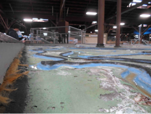
When geographers touch down in San Francisco this spring, they will encounter a socio-natural world produced in part through technical efforts to understand and manage it. As a primary means by which such efforts were pursued in the Bay Area during the postwar years, the San Francisco Bay-Delta Hydraulic Model – located a few miles north of the city in the town of Sausalito – offers a unique window into the formation of the metropolitan region. Built by the Army Corps of Engineers to simulate bay-estuary conditions and test the feasibility of development plans, the physical model now operates as an educational center and public showcase for the accomplishments of the Corps. Spread out over an acre in a former military shipbuilding warehouse and composed of hundreds of 12’ by 12’ concrete slabs, the model also constitutes a richly layered if seemingly anachronistic world onto itself. Passing through the Bay Model Visitor Center means confronting a vast terrain of miniature canals and levees, dikes and bridges, rivers and bays, and technical instruments and appurtenances that collectively target the bay and its watershed. Above the ebb and flow of the model’s mechanized tide, the whir of electric devices punctures the damp stillness of the air. Below it, rust steadily creeps throughout a labyrinth of channels. A landscape to traverse as much as a view to behold, the Bay Model promises to lend unique perspective on the world beyond the walls that house it.

At the turn of the millennium, rendered obsolete by advances in computer modeling, the Bay Model ceased operating in any official research capacity. Over its four-decade working life, however, the model generated important new understandings about the San Francisco Bay and Sacramento-San Joaquin Delta as “a complex estuarine system” (USACE 1993). To meet the needs of comprehensive planning, the Corps undertook an extensive survey of the Bay Area and constructed the replica landscape between 1956 and 1957 at a horizontal scale of 1:1,000 and a vertical one of 1:100. Originally encompassing a swath of the Pacific and the entire bay-estuary to the confluence of the Sacramento and San Joaquin rivers, the tool was designed to reproduce an average tidal cycle at a timescale of 14.9 minutes. But before it could be used to either simulate circulation patterns or forecast the effects of various reclamation and barrier proposals – such as the infamous Reber Plan to dam the bay (Wollenberg 2015) – the model had to be verified to known prototype conditions through a series of infrastructural interventions and measurements in the field. With the construction of the delta addition in the late 1960s, the model was mobilized to study the impact of dredging, channel realignment, and fresh-water diversion – still a source of conflict in California – on salinity intrusion and water quality. While running simulations initially required a team of seventy technicians to perform an intricate choreography of measurement and calculation, ongoing processes of instrumentation and the establishment of computerized control and data acquisition systems later allowed for greater operational flexibility. Today the model’s test-bed embodies the sedimentation of over forty years of technical practice.
As an engineering and planning tool, the Bay Model produced a number of effects that continue to animate political life the Bay Area. Most notably, it constituted the bay-delta system as an object of sustained inquiry and fixed the region as an appropriate scale of environmental management and administration. As early as 1967, Eugene Huggins and Edward Schultz of the San Francisco Army Engineer District pointed to the model as a primary means by which such realignments were achieved. On the one hand, they argued that simulations run on the model produced “the finest and most comprehensive library of data on the action and environment of the Bay now in existence” and provided “the foundation for almost all regional planning, by practically all agencies, in the Bay Area.” By offering a framework with which to probe the impact of individual projects on the bay-estuary and delta as a whole, the model, in their view, girded a broader scientific and popular shift in conceptions of the San Francisco Bay as an interconnected ecological system. Tellingly, data about the bay-delta system generated on the physical model, programmed into computers, continues to inform contemporary modeling exercises. On the other hand, in highlighting the intertwined fate of different Bay Area communities at the scale of nature, Huggins and Schultz suggested that the information produced on the model proved to be a “major stimulant…for the formation of regional authorities.” Indeed, the Bay Conservation and Development Commission, the Association of Bay Area Governments, and the Bay Area Council, among other regional organizations that guide development and promote policy in the Bay Area today, all drew upon studies conducted at the Bay Model and the expertise of the Corps more generally to support their institutional formation and governance agendas.

While the San Francisco Bay Model was but one of several large-scale hydraulic models built by the Corps of Engineers, it is the only one actively maintained. The outlines of Maryland’s Chesapeake Bay Model, opened in 1970s before rapidly falling into disuse and decay, might be gleaned from satellite images today. Likewise, the ruins of the massive Mississippi River Basin Model, itself a feat of engineering that targeted the Mississippi River and its major tributaries, can still be found in Clinton, Mississippi. Approved in 1943 and constructed with technical assistance from the Waterways Experiment Station and POW labor, the Basin Model – the ‘ur-model’ of the Corps’ mid-century hydraulic engineering program – embodied an important shift in approaches to water management. The Flood Control Act of 1936 charged the Corps with developing a more comprehensive solution to inundation than earlier piecemeal efforts to control individual rivers. “To understand the Mississippi River Basin as a dynamic system of interconnected waterways,” Kristi Dykema Cheramie suggests in an insightful essay, “the Corps needed new, more sophisticated tools” (2011). After successfully predicting the extent and impact of flooding in 1952, the test-bed was vindicated as a forecasting tool and mobilized to simulate flows throughout the watershed as a system. “The model,” Cheramie argues, “allowed the Mississippi River Basin to become, for the purposes of study, an object, a manageable site.” Like the San Francisco Bay Model, it promoted “a new scale of thinking” and demonstrated “the power of visualizations to shape policy through design.” With the development of “computational scripting and planning analysis technologies” in the 1970s, however, the Basin Model was “gradually upstaged by a mainframe computer in Sacramento.” In the 1990s, the Corps abandoned the model altogether, leaving it to be reclaimed by a pine forest.
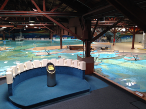
A combination of factors helps account for the preservation of the San Francisco Bay Model as well as its relative longevity as a research tool. First, unlike the Mississippi River Basin Model, the Bay Model’s test-bed was built upon a network of adjustable jacks in anticipation of seismic disturbances, allowing it to be continually re-calibrated to the shifting topography of the bay. The capacity to tune the model to fit changing conditions, combined with the fact that it remained sheltered within a controlled environment able to accommodate innovations, fostered the formation of a community of engineers willing to advocate for its continued relevance into the 1990s (Sinclaire 2011). Second, and perhaps most importantly, under the stewardship of William Angeloni, the model secured “Operation and Maintenance” funding in 1980. Rather than continuing to seek out financial support from project to project, federal apportionment gave the Bay Model stability as a site. Finally, while this funding provided for both the establishment of the Visitor Center and the facility’s eventual transformation into a tourist attraction, the model – from its inception – was understood to serve a pedagogical function. Built on location due to widespread enthusiasm for the project, it opened to ceremonious fanfare as a demonstration site where the public could learn about “the needs of a balanced ecology” and “hard data” might temper contentious debates over development and water policy (Huggins and Schultz 1967; Weisberg 2013). The model soon became – and still is – a regular stop on the school field-trip circuit. Yet, as Javier Arbona points out, both the aesthetic qualities of the model and the layout of its facility underwent subtle but important changes after 2000. Though framed today as an educational complex highlighting the region’s ecology and the importance of water conservation, the Visitor Center – with the model as its crown jewel – might just as well be understood as “a monument to the Army Corps” itself (Arbona and Woebken 2015).

Despite the new layers of paint, the framing devices, and the addition of an observation deck designed to render the structure legible, visiting the model today can still leave one feeling overwhelmed. Indeed, it’s not uncommon to spot marauding bands of children and their adult counterparts hurry past exhibits on natural history and WWII-era shipbuilding only to lose themselves within the abstract landscape of concrete bays and sculpted channels. While the model’s size, shape, and distorted scale combine to produce a sense of disorientation, its character as a relic or technological artifact of some bygone era bolsters this impression. It’s almost as though the model – a mere stone’s throw from the global epicenter of ‘disruptive innovation’ – got swept up in the storm of progress and dumped on shores of Richardson Bay in Sausalito. There’s something fitting, poignant even, about the un-timeliness of the model. After all, upon stepping out of the warehouse, one of the first things to confront visitors is a heaping mountain of wreckage. The Corps continues to run its “floating debris hazard collection” operations out of the Sausalito Base Yard, and it regularly deploys patrols to search for driftwood, sunken vessels, and rotting piers that might hinder navigation. Around ninety tons of detritus is pulled from the bay each month and loaded onto a dock in front of the Bay Model. There it sits, waiting to be trucked offsite for disposal. For the San Francisco District of the Army Corps of Engineers, progress literally entails the piling up of debris.
John Elrick is a PhD candidate at UC Berkeley. The Bay Model is located at 2100 Bridgeway, Sausalito, CA 94965. Additional information about the Bay Model Visitor Center can be found on its website.
References
Javier Arbona and Chris Woeboken, “Variable World: Bay Model Tour and Salon,” Avant.org, May 12, 2015.
The Center for Land Use Interpretation, “Chesapeake Bay Hydraulic Model,” Lay of the Land Newsletter, Spring 1998.
Kristi Dykema Cheramie, “The Scale of Nature: Modeling the Mississippi River,” Places Journal, March 2011.
Eugene Huggins and Edward Schultz, “San Francisco bay in a warehouse,” Journal of the Institute of Environmental Sciences and Technology, 10 (5) 1967.
Suzette McLeod and John McLeod, “This Too is Simulation,” Simulation in the Service of Society, December 1983.
Janice Sinclaire, “The Fitness of Physical Models,” Pacific Standard, December 5, 2011.
Charles Wollenberg, “The Man Who Helped Save the Bay By Trying to Destroy It,” Boom: A Journal of California, April 2015.
Michael Weisberg, Simulation and Similarity: Using Models to Understand the World. Oxford University Press, 2013.
US Army Corps of Engineers, San Francisco District, Comprehensive Survey of the San Francisco Bay and Tributaries, California. Appendix ‘H,’ Hydraulic Model Studies to the Interim Report on San Francisco Bay Barriers, Volume I of III (Figure 8). US Government Printing Office, March 1963.
US Army Corps of Engineers, San Francisco District, San Francisco Bay-Delta Tidal Hydraulic Model User’s Manual. US Government Printing Office, 1993.