The Kissimmee: A Tale of Three Rivers
In the central part of peninsular Florida, in a hot and humid place with lousy cell phone reception, lies a river on its third lifetime. The headwaters of this river, the Kissimmee, located near Orlando are filled with lakes formed in karst topography due to the presence of soluble limestone deposits near the surface. The upper basin drainage is comprised of river segments that connect lakes, like beads on a chain, and flows towards Lake Kissimmee, which is 141 km² (55 mi2) in area. The lower Kissimmee drainage flows between Lakes Kissimmee and Okeechobee, which some call “The Big O”, derived from a Seminole word meaning “big water”. Lake Okeechobee is shallow, averaging only 3m (9 ft) in depth, but covers 1,900 km2 (730 mi2), making it by area the largest freshwater lake in the state of Florida and the second largest freshwater lake contained entirely within the lower 48 states. This story overviews the three lifetimes of the Lower Kissimmee River. The first is that of a river with an unusual natural hydrology of prolonged flooding; in the second lifetime, the river was channelized for flood control creating “the Big Ditch,” now transitioning to its third lifetime as one of the world’s largest river restoration projects.
Historically, the Lower Kissimmee River had an unusual hydrology with prolonged flooding, several months in duration annually, due to the low regional slopes, the flow or drainage between these two large lakes and the occurrence of backwater from Lake Okeechobee. Many rivers overtop their banks for only a few days each year, some larger rivers may flood for a few months here and there, but the Kissimmee was flooding for a few months all years and in some years half the time or more. During this first life, the river corridor was a haven for fish and wildlife with at least 39 species of fish and 38 species of water birds, which thrived off a floodplain with prolonged flooding and water-filled areas of various types and sizes, including many secondary channels, sloughs, ponds, lakes and prairies. In the 1880s, there were some early efforts to modify the river by Hamilton Disston, a Pennsylvania industrialist and developer who had purchased of 16,000 km² (6200 mi2) of Florida land in 1881, one of the largest land purchases by a single person in world history (Godfrey and Catton, 2011). The Kissimmee was part of his work, and he performed some dredging and made two artificial cutoffs, but ultimately had minimal effect on the hydrology. Following the Okeechobee hurricane of 1928, the lowermost 10 km of the Kissimmee adjoining Lake Okeechobee were channelized, but the flooding was still mostly uncontrolled and allowed for a wet floodplain that supported diverse wildlife and aquatic biota.
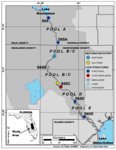
Over time, as the area became developed, cattle ranchers moved into the floodplain. Tropical cyclones came in cycles, and ranchers lost a lot of livestock during floods in the 1940s, in particular the flood of 1947. A report describing the damages featured a crying cow on the cover, prompting Congress to authorize in the following year the Central & Southern Florida Project for flood protection. The Kissimmee River portion of the project was authorized in 1954, and its planning and design then took place for several years until construction began in 1962. The project entailed creating a much straighter (166 to 90 km), deeper and larger capacity channel named C-38 across the middle of the floodplain, with the dredged material being deposited adjacent to the canal. Six water control structures (S-65 to S-65E) regulated inflow from the upper basin and divided the canal into reservoirs (Pools A-E), greatly reducing water level fluctuations (Figure 1). For the most part, the original Kissimmee River channel meanders were left intact, cutting back and forth across the new C-38 or “`Big Ditch” representing the second lifetime of the river. Water control structures and canals were built in the upper lakes region, which allowed for regulation of water flow within and between the lakes of the upper basin. The cost was $40 million, and the project was an engineering success. However, the alteration of the system’s hydrologic characteristics and the drainage of floodplain wetlands resulted in an environmental disaster with bird and wildlife populations plummeting over 90%. The lack of flow in the historic channel remnants increased floating exotic plants, organic and fine sediment accumulation, biological oxygen demand and nutrients, and decreased dissolved oxygen levels and fisheries in both the river and the lake. Stabilized water levels and reduced flow also eliminated river-floodplain interactions, spawning, and larval and juvenile refuge sites.
Although realization of this environment mistake was immediate, it took a few decades for the Kissimmee River Restoration Project to be authorized by Congress in the 1992 Water Resources Development Act. In its third life, the central portion of the Lower Kissimmee River is being restored by land acquisition, backfilling C-38 with its dredge spoil, rerouting flow back into the former historical channel, and removing two of the six structures (Figure 2). The project is being undertaken jointly by the South Florida Water Management District (SFWMD) and the US Army Corps of Engineers (USACE). Some call it the world’s largest river restoration project, with restoration defined by the National Research Council (1992) meaning the manipulation of the physical, chemical, or biological characteristics aiming to return natural/historic functions to a former or degraded aquatic resource. The channel reconfiguration of the Kissimmee River is a currently $980 million project, very large in magnitude for a river restoration project but small in comparison to the Everglades restoration, which will span 30 years and cost $13.5 billion at 2009 price levels (Secretary of the Army and the Secretary of the Interior 2011). The Kissimmee restoration is being done in phases, with the first beginning in 1999 and now the latter phase is underway with a current target completion date of 2015 (South Florida Water Management District, 2012), to be monitored for 5 years upon the end of construction to ensure restoration success. Floodplain inundation has returned, as have sand bars and several species of wading birds that disappeared. However, given upstream and downstream development and demands for water, plus the remaining human footprint, the restored river will be much improved ecologically from its channelized condition but remains a hybrid of its natural and altered form and function.
 Figure 2
Thus the Kissimmee River’s early past is unusual in the duration and magnitude of flooding, which then resulted in channelization and regulation of the river with structures to control these floods, and currently there is large river restoration undertaking for part of the system. Visiting the restored areas in the field is difficult, although bridges traverse some sections of the channelized areas. However, a virtual tour of the river on Google Earth© is recommended to compare differences in the restored system from the channelized system upstream and downstream. Also, there is a short video on a website that gives a brief overview of the area. Although there is no river like the Kissimmee, many other rivers in Florida also have interesting stories which you can learn more by attending one of the field trips at the annual meeting in Tampa.
—Joann Mossa
University of Florida
References
Godfrey, M.C. and Catton, T (2011) River of Interests: Water Management in South Florida and the Everglades, 1948-2010. Historical Research Associates Inc., US Government Printing Office, Washington, DC
National Research Council (1992) Restoration of Aquatic Ecosystems: Science, Technology, and Public Policy. National Academies Press, Washington, DC. DOI: 10.1002/iroh.19930780304.
Secretary of the Army and the Secretary of the Interior (2011) Comprehensive Everglades Restoration Plan 2010 Report to Congress.
South Florida Water Management District. 2012. https://www.sfwmd.gov/portal/page/portal/xrepository/sfwmd_repository_pdf/jtf_krr_progress.pdf