AI and GIS: Finally Delivering on the promise
The field of artificial intelligence (AI) isn’t new, and neither are its grand promises. AI as an academic pursuit has its roots in the 1950s. Early AI researchers were filled with optimism, but—despite some initial work that appeared groundbreaking, such as the first artificial neural networks—the field saw slow progress over the next several decades. By the mid-1970s, the field had hit a bit of a roadblock—there was a loss in interest largely due to inflated expectations as well as the failure to deliver on the promise of AI. This period is known as the first AI winter.
Following the first AI winter, advances in the field saw AI once again, albeit slowly, gaining momentum and funding, but only for a brief time. By the early-1990s, AI had again failed to live up to expectations. While AI had been tightly integrated into people’s everyday lives, it still largely failed on problems that most humans deem simple, such as recognizing features in images or understanding speech. With a 40-year history and a failure to live up to the hype, things appeared bleak for AI.
Then something happened. In the last decade, due to the advent of massive volumes of data gathered from the Internet and powerful graphics processing units (GPUs) capable of supercomputer-like performance on certain tasks, a particular type of AI algorithm has seen massive resurgence. These algorithms are known as artificial neural networks because they loosely resemble biological neural networks such as those in the human brain. Since 2010, these algorithms have experienced exponential increases in performance on numerous benchmarks, including some that were thought to be out of reach by many. Neural networks have even achieved superhuman performance in a few domains. Though still not quite reaching the level of promise visualized during the 1950s, AI is at the point where it is already making a massive impact everywhere. This includes in geographic information system (GIS) technology.
The types of data that we look at in the geospatial realm can be broadly categorized into two types: structured and unstructured. Structured data includes vector data—parcel boundaries, roads, GPS bread crumbs, and so on. Unstructured data refers to raster data, voice, and text, which—while typically very usable by humans—is difficult for machines to extract actionable information from.
This is changing rapidly; major advances in AI have made it possible to unlock the potential of unstructured data, and to do so at scale. Deep learning—so called because it applies “deep” artificial neural networks that often are composed of hundreds of connected layers of calculation—has enabled a new revolution in the processing of unstructured data. For those of us working in GIS, this means massive increases in productivity.

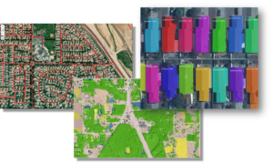
Deep learning has created the ability to very accurately detect objects and classify pixels at scale. Exploitation of aerial, satellite, and street-view images and videos are some of the common uses that we see at Esri. Deep learning enables endeavors such as large-scale high-resolution land cover mapping, the detection and digitization of buildings and roads, and rapid exploitation of drone imagery to detect asset damage, to name a few. Recent advances in processing voice and text by using deep learning allow geospatial analysis without manual extraction of geospatial entities. A fascinating new class of algorithms, called Generative Adversarial Networks (GAN), can generate realistic—but fake—data, including photographs! At Esri, we’ve been investigating numerous applications of GAN, ranging from generating 3D models to simulating spatiotemporal data and even performing automatic cartographic map styling, as shown at right.
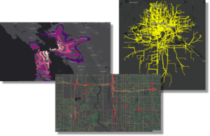
AI can also add value to structured data for tasks, including predicting geospatial events such as car crashes or crime, estimating drive times, or helping businesses determine where to construct the next new store. The list goes on—we are nowhere close to tapping all the potential of machine learning.
 The thing is, the GIS community has been using AI for a very long time. Performing regression, kriging, clustering, hot-spot analysis—these capabilities have been adopted into a subfield of AI called machine learning. Machine learning, at its core, is composed of approaches that learn from data rather than being explicitly programmed. Machine learning has been changing the world for decades, though it’s only recently that the public has started to become aware. This is mostly due to the emergence of deep learning.
Adoption of newer machine learning approaches into geospatial workflows has been slow. But why? As GIS practitioners know very well, GIS is hard—often, subtly so. While massive advances have been made in machine learning, very little thought has gone into making these approaches spatial. This leaves geographers shaking their heads in disapproval when geospatial processing is not only excluded from machine learning algorithms but may be flat-out ignored! Machine learning researchers and data scientists typically don’t understand the significant challenges that something as ubiquitous as terrain brings to the table when estimating the travel time between two locations. Furthermore, the appropriate distance between objects is often ignored or handled poorly. If close things are more related than distant things, machine learning often doesn’t treat this with any rigor.
To overcome these challenges, GeoAI—the combination of AI and GIS—is beginning to take off. Applying AI within a spatial context requires a new approach, but organizations are beginning to recognize the power that geography brings to the table. Sometimes this may mean preparing data differently to account for spatial challenges, and other times this may require a whole new approach. The AI team at Esri has been actively bringing these two fascinating fields together, but it’s in global action that there will be change.
AI hasn’t yet lived up to the original mission—to produce human-level intelligent machines—but it doesn’t have to! We don’t need human-level intelligence to make a human-level impact. AI is here, and it’s not going away this time.
To learn more about GeoAI, visit GeoAI on Medium or watch this video from the Esri Partner Conference.