
The Battle for SBE and Science Funding: What You Can Do

In early April, the White House published its proposed budget for Fiscal Year 2027. In its current form, the proposal threatens the core of U.S. scientific leadership; and if passed by Congress, would impose devastating cuts to programs supporting geography, climate, and spatial sciences.

These proposed reductions included a 55% cut to funding for the National Science Foundation (NSF), and the elimination of the Social, Behavioral, and Economic Sciences (SBE) directorate. The impact of this proposed elimination is already being felt, with Nature reporting that NSF leadership is moving to comply in advance by dissolving the directorate entirely, strictly on the basis of the White House request.

Historically, the Social, Behavioral, and Economic Sciences Directorate has been a cornerstone of funding for geographers, and social and psychological scientists, supporting nearly 63% of all academic research across those disciplines, but it suffers from an administrative hurdle that other directorates do not have: it was not statutorily established. SBE was established in the early 1990s because of years-long advocacy by social scientists who believed it should exist outside of the biology directorate. In 2017, NSF reaffirmed the value of SBE research to the nation’s priorities in a report that asserted  “The diverse SBE sciences that are supported at NSF—anthropology, archaeology, demography, economics, geography, linguistics, neuroscience, political science, psychology, sociology, and statistics—produce fundamental knowledge, methods, and tools for a greater understanding of people and how they live,” knowledge that forms a foundation for acting on national priorities in keeping with the NSF mission.

Nonetheless, SBE’s lack of statutory status reduces its legal and budgetary protections.

The Administration took similar measures in 2025, when it proposed the elimination of the directorate in the 2026 Budget. Due to push-back from many in the science community, including geographers, Congress took measures to limit these cuts, ensuring that the SBE would be able to operate at least through FY 2026.

This iteration of the administration’s budget proposal is likely to face a steep uphill climb in both halls of Congress, as it did in 2025, with members from both sides of the aisle articulating their support for sciences. We must continue to show our legislators that funding for spatial science matters.

What’s next?

In the past two weeks, the House and Senate Budget Committees held their first hearings with the Director of the Office of Management and Budget (OMB), Russell Vought. These were the first opportunities for the administration to defend the proposed cuts. During these marathon sessions, members from both sides of the aisle grilled the OMB Director on cuts to NSF, and other domestic agencies, voicing their displeasure with the impact that this would have on research across the board. Each chamber will work to draft and complete their concurrent budget resolutions by months-end.

In the month or so ahead, the budget will move through both Chambers’ appropriations committees, where it will be marked up for hopeful completion by the end of June. The subcommittees most important in determining how NSF, and SBE funds are appropriated include the House and Senate Subcommittees on Commerce, Justice, Science, and Related Agencies (CJS). The House Subcommittee will hold its markup on April 30, 2026, followed by a full House Appropriations Committee markup on May 13, 2026. Both will be public unless voted on as otherwise by committee members. Between these two Committee markups, the National Science Board (NSB) was scheduled to hold its next meeting on May 5th. This meeting has since been cancelled. As the governing body of NSF, the NSB’s perspectives on the budget are vital to helping Congress and the president understand which budgetary decision best align with the NSF’s mission. The NSB’s dismissal will have more consequential impacts as the budget process continues to unfold.

Congress must approve a budget, to be sent to the President’s desk by the 30th of September, or face a government shutdown.

What can you do?

  • Document how SBE funding has made an impact on your work, your institution, and especially your community and the nation. Send examples to advocacy@aag.org and use them in your communications with your Congressional representatives.
  • Reach out to your member of Congress, using tools like those provided by the Consortium of Social Science Associations, and AAG’s Action Kit to urge your member of Congress to recognize the importance of disciplines like geography to the nation’s long arc of innovation, and to express any concerns you may have related to the elimination of this crucial directorate of the NSF.
  • UPDATE: As of April 25th, 2026, the Administration has fired the entirety of the National Science Board, the governing body of the NSF. May’s meeting of the NSB has been cancelled. Please use tools like those provided by the Consortium of Social Science Associations, and AAG’s Action Kit to urge your member of Congress to recognizethe important role of this storied institution.
  • Encourage members of your network, such as department leaders, provosts, executives in the private sector, to be in touch and amplify your message.
  • Add your voice to the public dialogue on science funding. Many people in your community may not even know the stakes of this battle. Write an op ed, schedule a talk at your library, or share on social media. AAG’s Action Kit has ideas and how-to’s.

Stay alert to the appropriations process as it progresses, and stay in touch with AAG through advocacy@aag.org with your questions and ideas.

 

    Share

Member Profile: Phoebe Lind

Photo of Phoebe Lind

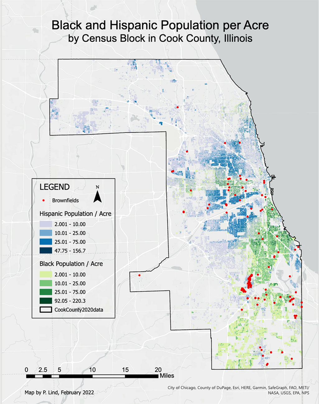
As a dancer and a geographer, Phoebe Lind’s career has been shaped by space and place. Most recently, her work as an enumerator for the U.S. Census Bureau, as a redistricting consultant for the Cook County Board, and as a recent graduate with a Masters degree in Geography and Environmental Sciences from Northeastern Illinois University, Lind has investigated the spatial relationship between environmental hazards and minority communities, and how they collectively inform the redistricting process.  

I‘ve always really enjoyed the science behind maps: how they’re made, how projections work, the way that they can be incredibly insightful to spatial trends of where problems exist in the world.

“I think I changed career paths because the world really needs people studying environmental issues, learning how to sufficiently use this amazing GIS technology that we have today, to start to fix all kinds of complicated problems that we are dealing with.” Lind earned her bachelor’s degree in Dance before deciding to pursue a Masters at NEIU. 

Lind’s academic research was inspired by a nationwide study that correlates the locations and traits of congressional districts relative to minority populations and Superfund sites. She decided to try to replicate the study herself, “or maybe develop a modified set of methods that could allow for this same study to be done on a county wide or similar scale, like a state or a city,” Lind explains, emphasizing the importance of scale. Lind’s own connection to the space she was studying—Cook County, where she lives—became clear as she moved through her research. “The reality for me is that I just have so much information on Cook County. And so much expertise on this redistricting process, because I did it. I did the redistricting process for this round of redistricting. I was an enumerator. I got to collect the data.” 

Phoebe Lind's map showing Black and Latino population locations in Cook County, Illinois

Working on the ground as an enumerator in Cook County during the beleaguered 2020 census did a great deal to inform how she carried out her research. “I had no idea what that job would be like, and it felt like a historic opportunity to kind of jump in and see how the process went. I feel really lucky to have been the one helping. This is important demographic and population data for the country…and then being able to see the other side of that and having input on the redistricting process…it felt like a very important job.”  

Are enough geographers in the room during the redistricting process? Lind thinks not. While processes differ from state to state, more geographers are needed everywhere to discuss the factors at play and help drive insights.  “I think the redistricting process would benefit from more GIS data analysts, and geographers. Politicians may be great at what they do, but they could be missing a lot of things that matter in the redistricting process. GIS is great at pointing those things that seem invisible until you put the table of data on a map and point it out to them saying, ‘this is the data and this is what it looks like spatially.’” 

When asked what she’ll do now that she has received her masters degree, she smiles. “I have a very nice problem where I’m interested in lots of different ways that I can use GIS…but since working with Cook County data, election data and election mapping have also been super interesting…I’m thinking I might want to go a little further with the study [I initiated], to see what I can change, what methods I can tweak. Maybe I can add onto it…because I think it has potential to grow a lot. But that’ll probably serve as kind of a side project to whatever job I end up doing, so the future is a little bit unknown. I’m pretty much just excited about GIS.” 

Find out more about AAG’s initiatives toward Geography for Inclusion 

Learn about AAG’s advocacy for Geography for Inclusion

    Share

Member Profile: Jovan Scott Lewis

Photo of Phoebe Lind

As a dancer and a geographer, Phoebe Lind’s career has been shaped by space and place. Most recently, her work as an enumerator for the U.S. Census Bureau, as a redistricting consultant for the Cook County Board, and as a recent graduate with a Masters degree in Geography and Environmental Sciences from Northeastern Illinois University, Lind has investigated the spatial relationship between environmental hazards and minority communities, and how they collectively inform the redistricting process.  

I‘ve always really enjoyed the science behind maps: how they’re made, how projections work, the way that they can be incredibly insightful to spatial trends of where problems exist in the world.

“I think I changed career paths because the world really needs people studying environmental issues, learning how to sufficiently use this amazing GIS technology that we have today, to start to fix all kinds of complicated problems that we are dealing with.” Lind earned her bachelor’s degree in Dance before deciding to pursue a Masters at NEIU. 

Lind’s academic research was inspired by a nationwide study that correlates the locations and traits of congressional districts relative to minority populations and Superfund sites. She decided to try to replicate the study herself, “or maybe develop a modified set of methods that could allow for this same study to be done on a county wide or similar scale, like a state or a city,” Lind explains, emphasizing the importance of scale. Lind’s own connection to the space she was studying—Cook County, where she lives—became clear as she moved through her research. “The reality for me is that I just have so much information on Cook County. And so much expertise on this redistricting process, because I did it. I did the redistricting process for this round of redistricting. I was an enumerator. I got to collect the data.” 

Phoebe Lind's map showing Black and Latino population locations in Cook County, Illinois

Working on the ground as an enumerator in Cook County during the beleaguered 2020 census did a great deal to inform how she carried out her research. “I had no idea what that job would be like, and it felt like a historic opportunity to kind of jump in and see how the process went. I feel really lucky to have been the one helping. This is important demographic and population data for the country…and then being able to see the other side of that and having input on the redistricting process…it felt like a very important job.”  

Are enough geographers in the room during the redistricting process? Lind thinks not. While processes differ from state to state, more geographers are needed everywhere to discuss the factors at play and help drive insights.  “I think the redistricting process would benefit from more GIS data analysts, and geographers. Politicians may be great at what they do, but they could be missing a lot of things that matter in the redistricting process. GIS is great at pointing those things that seem invisible until you put the table of data on a map and point it out to them saying, ‘this is the data and this is what it looks like spatially.’” 

When asked what she’ll do now that she has received her masters degree, she smiles. “I have a very nice problem where I’m interested in lots of different ways that I can use GIS…but since working with Cook County data, election data and election mapping have also been super interesting…I’m thinking I might want to go a little further with the study [I initiated], to see what I can change, what methods I can tweak. Maybe I can add onto it…because I think it has potential to grow a lot. But that’ll probably serve as kind of a side project to whatever job I end up doing, so the future is a little bit unknown. I’m pretty much just excited about GIS.” 

Find out more about AAG’s initiatives toward Geography for Inclusion 

Learn about AAG’s advocacy for Geography for Inclusion

    Share