MyCOE / SERVIR Capstone Fellows Describe Their Experiences
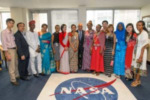
The event was a culmination of a global program carried out over the past two years, with representative student-led projects highlighting how youth around the world are using remote sensing, GIS, GPS, and geospatial data to address climate change issues in their regions. The 14 students were selected from the 120 participants who were nominated by instructors and staff of the MyCOE Program and SERVIR hubs and chosen by U.S. Agency for International Development (USAID) and NASA.
View the inspiring testimonials from these fellows:
Khin Seint Seint Aye, Impact of famous floating gardens on the environment and livelihoods of a unique Inle lake in Central Myanmar
Susan Malaso, Application of GIS and RS Techniques in Frost Risk Mapping for Mitigating Agricultural Losses in Kenya
Lhakpa, Linking Traditional Beliefs on Climate Change to Scientific Understanding: A Case Study in Eastern Bhutan
Tsedenya Abebe Mengiste, Assessment of Flood Frequency and Local Adaptation Practices in Dilu-Meda, Upper Awash, Ethiopia
Prasamsa Thapa, Surface Area Variation and Climatology of Tsho Rolpa Glacial Lake using Remote Sensing and GIS, Dolakha District, Nepal
Jirawat Panpeng, Vulnerability of Rural Coastal to Potential Sea Level Change: Case of Laemsing District, Chanthaburi Province, Thailand
Roseline Nijh Egra Batcha, Participatory Learning and Gender Partnerships in Climate Change and Food Security: Mfoundi-Yaounde Cameroon
Joyeeta Poddar, Assessment of Glacier Health as a Response to Climate Change in Western Himalayas, India
Khoa Nguyen, Changes of paddy rice extent and its possible effect on the environment in Mekong Delta, Vietnam
Seble Dejene, Carbon Stock Estimation in Wof-Washa Natural Forest: Carbon Finance Options & Climate Change Mitigation, Ethiopia
Pramila Paudyal, Climate Change Vulnerability in Mountain Agriculture: A Case Study Of Susma Chhemawati VDC, Dolakha District, Nepal
Wasiu Alimi, Assessment of the Climatic and Socio-Economic Impacts of Illegal Logging in a Rainforest: The Role of Women, Nigeria
Lateefah Oyinlola, Assessment of vulnerabilities of fresh cut produce to climate change in South Western Nigeria
Tran Thi Mai Anh, Application of GIS and Remote Sensing in Administering Payment For Forest Environmental Services at Huong Son Hydroelectric Power Plant’s Watershed, Vietnam
The MyCOE / SERVIR program supports long-term training of young, emerging scholars in the use of Earth observations, geography, and geospatial technologies to address climate change issues in developing regions. The public-private partnered program provides the mentorship, networking, and professional development necessary to transform innovators into scholars, with the skills to connect their research results to the public and decision makers. It is sponsored by NASA, USAID, and AAG, with the AAG also administering the program. SERVIR, an acronym meaning “to serve” in Spanish, is a joint venture between NASA and USAID. SERVIR works in partnership with leading regional organizations around the globe to help developing countries use information provided by Earth-observing satellites and geospatial technologies to better manage climate risks and sustainability of natural resources.
To learn more about the full My Community, Our Earth / SERVIR program, contact Project Director Dr. Patricia Solís at psolis [at] aag [dot] org. Or, visit https://www.aag.org/mycoe.servir. Read more detailed information on the NASA event.