New NSF REU Experience for Undergraduates: Community GIS and Citizen Science in Belize
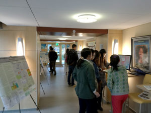
This summer at the University of Central Florida, we are pleased to host the first year of our National Science Foundation Research Experiences for Undergraduates (REU) Site “Preparing the Next Generation of Scholars through Community GIS and Citizen Science.” Our program offers fully funded summer research experiences for at least 8 undergraduate students in Belize for 5 weeks and Orlando for two weeks. The program is open to all U.S. students and runs June 20-August 5, 2016. We are interdisciplinary in nature emphasizing community geography, community GIS, and citizen science through mixed methods, including sketch mapping, mobile mapping applications, focus groups, in-depth interviews, GIS, and spatial analysis. Please distribute to interested students and your networks.
Research opportunities: Students will work in one of two research directions with community partners and mentors from University of Central Florida, University of Belize, Georgia State University, and The Smithsonian National Museum of Natural History’s Caribbean Coral Reef Ecosystems Program:
Research Direction 1: Mapping disparities in flooding & disaster management
Research Direction 2: Mapping marine debris & mitigating impacts on coastal communities
Compensation: Each REU student will receive a competitive funding package, including a $3500 research stipend, $1400 meal allowance, free shared housing in Belize and Orlando, up to $750 in travel support to/from the REU Site, up to $750 for post-REU conference travel, and 2 research methods books.
Application process: The priority application deadline is Friday, March 25th @ 5 PM EST. Complete program information and application instructions can be found at https://www.citizensciencegis.org/ucf-reu-site/.
Student reflections from the field: “Challenging, emotional, fun, collaborative, thought-provoking, interesting, real-life, and eye-opening.” These are some of the words used by students to describe our previous research programs. We expect similar experiences in our new REU! Check out a series of short videos from our students at:https://www.citizensciencegis.org/ucf-reu-site/student-reflections/.
Questions can be directed to:
Dr. Timothy Hawthorne: Principal Investigator, Assistant Professor of Geographic Information Systems at University of Central Florida
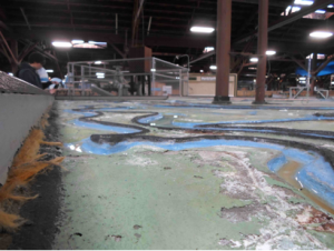
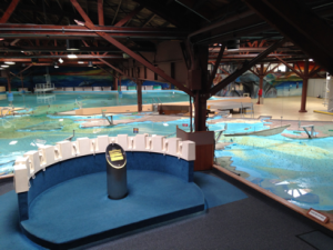
When geographers touch down in San Francisco this spring, they will encounter a socio-natural world produced in part through technical efforts to understand and manage it. As a primary means by which such efforts were pursued in the Bay Area during the postwar years, the San Francisco Bay-Delta Hydraulic Model – located a few miles north of the city in the town of Sausalito – offers a unique window into the formation of the metropolitan region. Built by the Army Corps of Engineers to simulate bay-estuary conditions and test the feasibility of development plans, the physical model now operates as an educational center and public showcase for the accomplishments of the Corps. Spread out over an acre in a former military shipbuilding warehouse and composed of hundreds of 12’ by 12’ concrete slabs, the model also constitutes a richly layered if seemingly anachronistic world onto itself. Passing through the Bay Model Visitor Center means confronting a vast terrain of miniature canals and levees, dikes and bridges, rivers and bays, and technical instruments and appurtenances that collectively target the bay and its watershed. Above the ebb and flow of the model’s mechanized tide, the whir of electric devices punctures the damp stillness of the air. Below it, rust steadily creeps throughout a labyrinth of channels. A landscape to traverse as much as a view to behold, the Bay Model promises to lend unique perspective on the world beyond the walls that house it.
Model Diagram. From McLeod and McLeod, 1983.
At the turn of the millennium, rendered obsolete by advances in computer modeling, the Bay Model ceased operating in any official research capacity. Over its four-decade working life, however, the model generated important new understandings about the San Francisco Bay and Sacramento-San Joaquin Delta as “a complex estuarine system” (USACE 1993). To meet the needs of comprehensive planning, the Corps undertook an extensive survey of the Bay Area and constructed the replica landscape between 1956 and 1957 at a horizontal scale of 1:1,000 and a vertical one of 1:100. Originally encompassing a swath of the Pacific and the entire bay-estuary to the confluence of the Sacramento and San Joaquin rivers, the tool was designed to reproduce an average tidal cycle at a timescale of 14.9 minutes. But before it could be used to either simulate circulation patterns or forecast the effects of various reclamation and barrier proposals – such as the infamous Reber Plan to dam the bay (Wollenberg 2015) – the model had to be verified to known prototype conditions through a series of infrastructural interventions and measurements in the field. With the construction of the delta addition in the late 1960s, the model was mobilized to study the impact of dredging, channel realignment, and fresh-water diversion – still a source of conflict in California – on salinity intrusion and water quality. While running simulations initially required a team of seventy technicians to perform an intricate choreography of measurement and calculation, ongoing processes of instrumentation and the establishment of computerized control and data acquisition systems later allowed for greater operational flexibility. Today the model’s test-bed embodies the sedimentation of over forty years of technical practice.
Tide Generator at the Bay Model. From USACE, 1963.
As an engineering and planning tool, the Bay Model produced a number of effects that continue to animate political life the Bay Area. Most notably, it constituted the bay-delta system as an object of sustained inquiry and fixed the region as an appropriate scale of environmental management and administration. As early as 1967, Eugene Huggins and Edward Schultz of the San Francisco Army Engineer District pointed to the model as a primary means by which such realignments were achieved. On the one hand, they argued that simulations run on the model produced “the finest and most comprehensive library of data on the action and environment of the Bay now in existence” and provided “the foundation for almost all regional planning, by practically all agencies, in the Bay Area.” By offering a framework with which to probe the impact of individual projects on the bay-estuary and delta as a whole, the model, in their view, girded a broader scientific and popular shift in conceptions of the San Francisco Bay as an interconnected ecological system. Tellingly, data about the bay-delta system generated on the physical model, programmed into computers, continues to inform contemporary modeling exercises. On the other hand, in highlighting the intertwined fate of different Bay Area communities at the scale of nature, Huggins and Schultz suggested that the information produced on the model proved to be a “major stimulant…for the formation of regional authorities.” Indeed, the Bay Conservation and Development Commission, the Association of Bay Area Governments, and the Bay Area Council, among other regional organizations that guide development and promote policy in the Bay Area today, all drew upon studies conducted at the Bay Model and the expertise of the Corps more generally to support their institutional formation and governance agendas.
The Mississippi River Basin Model. Photo: John Elrick.
While the San Francisco Bay Model was but one of several large-scale hydraulic models built by the Corps of Engineers, it is the only one actively maintained. The outlines of Maryland’s Chesapeake Bay Model, opened in 1970s before rapidly falling into disuse and decay, might be gleaned from satellite images today. Likewise, the ruins of the massive Mississippi River Basin Model, itself a feat of engineering that targeted the Mississippi River and its major tributaries, can still be found in Clinton, Mississippi. Approved in 1943 and constructed with technical assistance from the Waterways Experiment Station and POW labor, the Basin Model – the ‘ur-model’ of the Corps’ mid-century hydraulic engineering program – embodied an important shift in approaches to water management. The Flood Control Act of 1936 charged the Corps with developing a more comprehensive solution to inundation than earlier piecemeal efforts to control individual rivers. “To understand the Mississippi River Basin as a dynamic system of interconnected waterways,” Kristi Dykema Cheramie suggests in an insightful essay, “the Corps needed new, more sophisticated tools” (2011). After successfully predicting the extent and impact of flooding in 1952, the test-bed was vindicated as a forecasting tool and mobilized to simulate flows throughout the watershed as a system. “The model,” Cheramie argues, “allowed the Mississippi River Basin to become, for the purposes of study, an object, a manageable site.” Like the San Francisco Bay Model, it promoted “a new scale of thinking” and demonstrated “the power of visualizations to shape policy through design.” With the development of “computational scripting and planning analysis technologies” in the 1970s, however, the Basin Model was “gradually upstaged by a mainframe computer in Sacramento.” In the 1990s, the Corps abandoned the model altogether, leaving it to be reclaimed by a pine forest.
The Bay Model from on high. Photo: John Elrick.
A combination of factors helps account for the preservation of the San Francisco Bay Model as well as its relative longevity as a research tool. First, unlike the Mississippi River Basin Model, the Bay Model’s test-bed was built upon a network of adjustable jacks in anticipation of seismic disturbances, allowing it to be continually re-calibrated to the shifting topography of the bay. The capacity to tune the model to fit changing conditions, combined with the fact that it remained sheltered within a controlled environment able to accommodate innovations, fostered the formation of a community of engineers willing to advocate for its continued relevance into the 1990s (Sinclaire 2011). Second, and perhaps most importantly, under the stewardship of William Angeloni, the model secured “Operation and Maintenance” funding in 1980. Rather than continuing to seek out financial support from project to project, federal apportionment gave the Bay Model stability as a site. Finally, while this funding provided for both the establishment of the Visitor Center and the facility’s eventual transformation into a tourist attraction, the model – from its inception – was understood to serve a pedagogical function. Built on location due to widespread enthusiasm for the project, it opened to ceremonious fanfare as a demonstration site where the public could learn about “the needs of a balanced ecology” and “hard data” might temper contentious debates over development and water policy (Huggins and Schultz 1967; Weisberg 2013). The model soon became – and still is – a regular stop on the school field-trip circuit. Yet, as Javier Arbona points out, both the aesthetic qualities of the model and the layout of its facility underwent subtle but important changes after 2000. Though framed today as an educational complex highlighting the region’s ecology and the importance of water conservation, the Visitor Center – with the model as its crown jewel – might just as well be understood as “a monument to the Army Corps” itself (Arbona and Woebken 2015).
The Angel of History at Richardson Bay. Photo: John Elrick.
Despite the new layers of paint, the framing devices, and the addition of an observation deck designed to render the structure legible, visiting the model today can still leave one feeling overwhelmed. Indeed, it’s not uncommon to spot marauding bands of children and their adult counterparts hurry past exhibits on natural history and WWII-era shipbuilding only to lose themselves within the abstract landscape of concrete bays and sculpted channels. While the model’s size, shape, and distorted scale combine to produce a sense of disorientation, its character as a relic or technological artifact of some bygone era bolsters this impression. It’s almost as though the model – a mere stone’s throw from the global epicenter of ‘disruptive innovation’ – got swept up in the storm of progress and dumped on shores of Richardson Bay in Sausalito. There’s something fitting, poignant even, about the un-timeliness of the model. After all, upon stepping out of the warehouse, one of the first things to confront visitors is a heaping mountain of wreckage. The Corps continues to run its “floating debris hazard collection” operations out of the Sausalito Base Yard, and it regularly deploys patrols to search for driftwood, sunken vessels, and rotting piers that might hinder navigation. Around ninety tons of detritus is pulled from the bay each month and loaded onto a dock in front of the Bay Model. There it sits, waiting to be trucked offsite for disposal. For the San Francisco District of the Army Corps of Engineers, progress literally entails the piling up of debris.
John Elrick is a PhD candidate at UC Berkeley. The Bay Model is located at 2100 Bridgeway, Sausalito, CA 94965. Additional information about the Bay Model Visitor Center can be found on its website.
US Army Corps of Engineers, San Francisco District, Comprehensive Survey of the San Francisco Bay and Tributaries, California. Appendix ‘H,’ Hydraulic Model Studies to the Interim Report on San Francisco Bay Barriers, Volume I of III (Figure 8). US Government Printing Office, March 1963.
US Army Corps of Engineers, San Francisco District, San Francisco Bay-Delta Tidal Hydraulic Model User’s Manual. US Government Printing Office, 1993.
With large-scale demand and a mission to protect public health, hospitals are emerging as the next frontier of the sustainable food movement. Health care institutions spend $12 billion in the food and beverage sector each year,1 and a single hospital can have an annual food budget of $1–7 million or more.2 Even small shifts in foodservice budgets can create new markets for alternative foods.
To date, the darlings of the food movement have been farmers’ markets, Community Supported Agriculture (CSA) programs, and urban farms that connect eaters directly with the source of their food. These models appear to have boosted the number of small farmers in the U.S. after decades of freefall,3 but research shows that we now have an increasingly bifurcated system that favors small-scale direct markets and large-scale commodity markets. What’s more, experts believe that direct market models are reaching a saturation point even though they’ve barely begun to scratch the surface of the agricultural status quo. Local food sales account for less than two percent of total farm gross, and the goods exchanging hands at some 7,800 farmers’ markets nationwide represent less than one percent of total U.S. agricultural production.4
Meanwhile, mid-sized family farmers are being squeezed out by the march of consolidation within the food system, as are independent middlemen that aggregate, process, and distribute food regionally.5 This agriculture of the middle, meaning mid-sized family farmers and mid-level food system intermediaries, represents the most threatened set of entities in the agricultural sector. Direct market models hold little sway in solving this problem, they are too small to support mid-sized farmers, and they purposefully cut out middlemen.
Leading-edge food system advocates are looking to institutional buyers like hospitals, schools, and universities to help rebuild this missing middle ground because they buy in large volumes and they rely on the wholesalers, processors, and distributors that make up the functional infrastructure of the U.S. food system. But the leap in scale from an individual buying three onions at a farmers’ market to a hospital buying three hundred cases is not simply one of numbers, it presents an entirely different set of challenges, opportunities, and relationships. When you’re making soup for six hundred, changing your grocery list quickly gets complicated.
A team of San Francisco Bay Area hospitals have been at the vanguard of this institutional food revolution since 2005. Leaders including Kaiser Permanente, University of California at San Francisco Medical Center, John Muir Health, and the San Francisco VA Medical Center, gathered at the FoodMed Conference in Oakland, California that year. A non-profit organization called Health Care Without Harm convened leaders from the sustainable agriculture, environmental health, public health, and health care sectors to discuss their overlapping concerns and goals. Together, they articulated a systemic environmental nutrition approach to healthy food, going beyond counting calories and balancing food groups to address the many ways the food system impacts public health.
Since then, over 550 hospitals nationwide, they have signed a Healthy Food in Health Care Pledge generated by the nonprofit coalition Health Care Without Harm (HCWH) which states that “for the consumers who eat it, the workers who produce it and the ecosystems that sustain us, healthy food must be defined not only by nutritional quality, but equally by a food system that is economically viable, environmentally sustainable, and supportive of human dignity and justice.”
Hospitals are putting this vision into practice by serving local produce when it’s in season, switching to rBGH-free dairy products, and sourcing seafood from community-based fisheries. They are buying fair trade coffee, cage-free eggs, and organic salad greens. Some are reducing meat servings to lower their greenhouse gas footprint and are using the cost savings to buy grass-fed beef and free-range chicken raised without antibiotics or added hormones.
“Local, organic chicken was a real challenge” says one leading Bay Area Hospital Food and Nutrition Services Director. Under the current system, he can place an order on his food distributor’s website, and the next day hundreds of uniform 4-ounce chicken breasts show up on his loading dock, shrink-wrapped and stacked by the case. Procuring local, organic chicken first required weeks of working through bureaucratic purchasing and legal systems to set up a new vendor relationship. When the hospital finally received its first delivery, it was an ice-packed box of whole chickens with the heads and feet still on. “My cooks almost died,” he reports. Having to chop off chicken heads is a far cry from lining up a row of boneless, skinless meat parts in the griller. Most institutional kitchens no longer have the equipment or staff with the knowledge necessary to deal with whole foods.
The pallets of uniform poultry parts that come through national distributors like Sysco and US Foods also help hospitals to meet strict federal dietary guidelines, as each cut arrives within a fraction of the weight ordered. In contrast, locally-sourced chicken breasts, even if they arrive pre-processed, might come in a four to eight ounce range, forcing staff to slice and individually weigh servings. With tight budgets, paying staff to mete out perfect portions may not be time that a hospital foodservice department can afford.
Efficiency has been a dirty word in some food movement circles, but a little efficiency goes a long way when you’re serving hundreds to thousands of meals every day. Equally blasphemous has been middlemen. But buying food at the institutional scale means relying on certain industrial-style standards and relationships. Hospitals are a microcosm of the challenges that face the alternative food movement as it seeks to scale up — they need to balance their sustainable food goals with their need for efficiency and affordability.
Initiatives like the Farm Fresh Healthcare Project offer insight into how leading hospitals are working with distributors to retrofit existing supply chains to become shorter, more flexible, and more transparent. Since 2011, a team of hospitals in the San Francisco Bay Area have partnered with Health Care Without Harm and Community Alliance with Family Farmers to source more local and organic produce from family farmers.
Beyond purchasing power, hospitals can leverage another form of currency in support of organic agriculture – moral authority. Polls consistently show that health professionals rank as some of the most trusted experts in the United States. [1] They can “tell stories about great farmers,” as Luis Vargas, Procurement Manager for Nutrition and Food Services at University of San Francisco Medical Center says, “People look to us for this leadership, and we should be showing the way.” Like the first hospitals to ban smoking on their grounds, which led to greater public awareness and smoking restrictions in other locations,6 those that are leading the environmental nutrition movement are enacting changes that will have ripple effects throughout society.
David de Laubenfels, emeritus professor in the Department of Geography at Syracuse University, and a biogeographer who was an expert on tropical conifers, passed away on February 6, 2016, at the age of 90.
David John de Laubenfels was born in 1925 in Pasadena, California. His father, Max Walker de Laubenfels, was a noted marine biologist which perhaps influenced the development of David’s interests in the natural world.
After serving in the Quartermaster Corps of the United States Army during the Second World War, de Laubenfels attended Colgate University, NY. As part of his undergraduate studies, he completed “A Geographic Study in the Hamilton Area, New York.” Having graduated in 1949 he moved to the University of Illinois for postgraduate studies. His master’s degree, completed in 1950, included a thesis entitled “Marketing Geography of Open Display Cold Storage Equipment” while his doctorate dissertation, completed in 1953, was entitled “The Temuco Region, A Geographic Study in South Central Chile.” Despite the subject matter of these three studies, he was already gravitating towards physical geography and, more particularly, to biogeography.
His first professional appointment was at the University of Georgia, starting as Assistant Professor in 1953 and moving to Associate Professor in 1958. In 1959 he joined the faculty at Syracuse University where he remained for the rest of his career, attaining the rank of full Professor in 1971 and retiring as Professor Emeritus in 1993.
De Laubenfels studied the variation of vegetation from place to place. Among his many publications in biogeography are the books A Geography of Plants and Animals (1970) and Mapping the World’s Vegetation: Regionalization of Formations and Flora (1975).
He carried out various studies in the United States, publishing articles on the soil and vegetation of New York State, the characteristics of the Ozark Upland in the Midwest, the nature and boundaries of the Corn Belt, conifers of southeast, and the semi-tropical woodland of Georgia. He also did a comparative study of Australian forests with vegetation of similar climatic areas in the Americas.
However, it is for his work on the taxonomy of conifers, particularly tropical conifers, that de Laubenfels is known throughout the world. In carrying out his studies, he traveled whenever possible to the actual locations where the plants were established so that he could see them in their many natural growth forms. He had a particular interest in the south Pacific, carrying out field expeditions to locations including New Caledonia, Fiji, Papua New Guinea and the Moluccas. New Caledonia was of particular interest due to the rare conifers there; on one of his expeditions he discovered a parasitic conifer and published his finds in Science (1959). He also studied conifers in Latin America including Costa Rica, Venezuela, Peru and Uruguay.
His first major taxonomic revision in conifers was published in 1969: “A Revision of the Malesian and Pacific Rainforest Conifers, I Podocarpaceae.” In 1972, his chapter on “Gymnospermes” published in Flore de la Nouvelle-Caledonie et Dependances was a seminal piece of work because of the importance and uniqueness of this group of plants. Another major taxonomic publication, Coniferales, Flora Malesiana was published in 1988. Over the years, de Laubenfels identified over 100 new species in the tropics; in the photograph above he is examining Podocarpus beecherae, one of those he named. He also had one species named in his honor – Araucaria laubenfelsii, commonly known as the De Laubenfels’ araucaria – which is native to southern New Caledonia.
Outside of his taxonomic and plant geography work, de Laubenfels had a wide variety of interests on topics such as the geographic origins of human development and the origins of language. He also published a book on physics entitled It’s Hard to Believe in Infinity (1992). Meanwhile in another work, “Where Sherman Passed By” (1957), he highlighted General Sherman’s march through Georgia, walking the entire route using the maps of his great-grandfather, John (Rziha) Laube de Laubenfels, chief topographical engineer for one of Sherman’s columns.
De Laubenfels joined the American Association of Geographers in 1949 and was involved in the Regional Division that included New York State, presenting papers at regional meetings including “Plant Geography Versus Vegetation Geography” (1962) and “The Variations of Vegetation from Place to Place” (1968).
He was also a member of the American Conifer Society and British Conifer Society. His love of nature was reflected locally too: he was a long-time member of the Onondaga chapter of the Adirondack Mountain Club.
David de Laubenfels will be remembered for his major contributions to biogeography and his unparalleled expertise in tropic conifers. He had a remarkable career, with academic publications spanning from 1950 to 2015 when he was in his 90th year.
He is survived by his loving wife, Janet, three daughters, five step-children, several grandchildren and two great-grandchildren, as well as three siblings. He was predeceased by his son, Eric.
Now is the winter of our discontent. I have always liked that line, the first of King Richard III. I know it is not really about winter, but it has always evoked for me the vaguely uncomfortable feeling I have during this season. It is cold, the days are short, and all I want to do is hibernate. But here in Texas we are seeing the first signs of spring. Yes, at the end of January. The robins are back, passing through on their way north; the narcissuses are about to bloom; and the trees are budding. Hope is in the air as I write this column. So let me write about two different topics, hiring and award selection. I promise to end each topic with an optimistic twist.
Budding oak tree, January 30, 2016, College Station, Texas
First, I am conscious of the anxiety and discontent of many young geographers who are completing their dissertations (stressful enough on its own) and applying for academic positions or other employment. Hiring is one of the most important things that a department does and yet we often do it without much reflection or consideration of the applicants. Tradition drives the process and I think we become a little callous. After all, we have been through the process ourselves and survived. In the last few months, as I have traveled and talked to many young people, I have heard incredible hiring stories. The Chronicle of Higher Education has had a series of columns about hiring entitled, “Academic Job Hunts from Hell” that confirm what I have heard, especially about faux searches, that is, searches with a favored internal candidate, and cringe-worthy, uncomfortable job interviews fraught with illegal (and downright offensive) personal questions and comments. It occurs to me that we may not be conscious of how inconsiderate—or inappropriate—we are.
We are also not conscious of the forms of implicit bias we practice in the hiring process. Project Implicit, a research project housed at Harvard, offers a series of tests and resources related to implicit bias. We are all biased, but these tests help us to understand our predilections or shortcomings. The classic study, Why So Slow by Virginia Valian, is a great resource for all geography faculty engaged in hiring. Too often we self-censor our selection process. We think, for example, a single young woman won’t be “happy” in a small, remote college town, so don’t select that person. We reject individuals who we perceive won’t “fit” early in the process rather than leaving it up to the applicant to make a decision. So we have two issues: inconsiderate hiring practices and inherent biases in hiring procedures.
The positive twist here is that there are resources and guides to assist in the process. Nothing will stop some of your colleagues from asking awkward questions or being biased, implicitly or explicitly, but you can work to improve the process for everyone. A recent Chronicle article, The Art of Rejection, offers suggestions about how to write a kind and gentle rejection letter, for example. In addition, the Job Hunts from Hell series, while written from the perspective of applicants, offers sage advice for the interviewers. Finally, the NSF-funded ADVANCE program at the University of Michigan is a treasure trove of best practices in hiring, including applicant and candidate evaluation forms. The use of uniform assessments in the hiring process is one proven way to counter bias.
Second, and related to my comments about bias, I received generally positive responses to my suggestion to initiate an AAG Fellows honors program. Several people, however, expressed concerns about equity and equality in the selection process. How will this not perpetuate existing elites, I was challenged. Can we formulate a program that truly recognizes a range of contributions to our profession? As part of the program proposal development, I have researched other professions’ programs and resources related to equity in selection of professional awards. The American Psychological Association hosts workshops at its annual meetings to assist Fellows nominees and to train selection committees. The University of Michigan provides a particularly useful document outlining both the principles that should guide award selection processes and best practices. The principles include fairness, inclusiveness, and accountability. To ensure equity, if this program is initiated, we will have to ensure that the pool of nominees is as broad as possible, and not just “the usual suspects.” Another key principle will be education to counter bias. We will have to ensure that the group of people making the selection process are prepared to grapple with their personal, academic, and institutional prejudices.
It is here that best practices come into play. We will have to appoint or elect a diverse selection committee, specify clear criteria for selection, and have a process that is open and transparent, with multiple ways for individuals to be nominated. The decision-making process will have to abide by the stated principles, be thoughtful, inclusive, and respect the perspectives of all committee members. I am writing this, which is probably obvious, to let you know that Council will be taking all of these ideas into account when they consider a Fellows Program. So the positive twist is that while prejudice and bias persists, there are strategies and resources to work against their pernicious effects. Hope springs eternal in the human breast.
Harold Rose, distinguished professor emeritus of geography and urban studies at the University of Wisconsin-Milwaukee, and pioneer in research on race and segregation, passed away on February 2, 2016, at the age of 86.
Harold Milton Rose was born on January 8, 1930 in Nashville, Tennessee. He was raised by his grandparents, of whom his grandfather worked in a phosphate mine and his grandmother as a domestic.
Despite skipping several grades in school, he went to college at the age of 16 – somewhat by chance – having had heard that a friend had applied to Tennessee State, a historically black college, and been accepted. Rose paid his way through his four years of college by working in the cafeteria every day.
Having graduated with a degree in history and geography in 1950, Rose spent time in the Army then returned to Tennessee State to take some further geography courses. There he was encouraged by a professor to apply for a master’s program at Ohio State University.
He taught for a few years at Florida A&M University in Tallahassee, also a historically black college, before returning to Ohio State University for a doctorate in geography. His thesis, completed in 1960, was entitled “An Analysis of Land Use in Central-North Florida: A Study in Conservation.”
In 1962, Rose received a joint appointment in the departments of geography and urban affairs at the University of Wisconsin-Milwaukee (UWM), one of the first tenured African American professors at the university. Although he was sought by other universities, Rose spent his entire career at UWM. This included serving as chair of the Department of Urban Affairs (1970-1973 and 1974-1977), Department of Afro-American Studies (1977-1978), and Department of Geography (1990-1994).
Although Rose began his academic career exploring issues of natural resource management, he shifted focus after arriving in Milwaukee in 1962. He had moved to a deeply segregated city during a time of heightened civil rights activism around housing and school segregation. He pioneered research on the conditions faced by African Americans and went on to build a national reputation in the field, specifically how racism and racial policy affected urbanization.
Rose’s foundational work on racial discrimination and segregation challenged urban geographers to consider the ghetto as produced through both spatial and social processes. His scholarship established that examining segregation was not just about mapping the distribution of racial groups across the urban landscape, but also about understanding the social processes and attitudes about race that produced those patterns.
He conducted community-engaged research field research on the quality of life in black communities, the black ghetto, black residential mobility and interregional migration, high rates of homicide in many black communities, and the experience of blacks and Cubans in Miami.
Among his many publications on race, segregation and violence were the books “The Black ghetto: a spatial behavioral perspective” (1971), “Black Suburbanization: Access to Improved Quality of Life or Maintenance of the Status Quo?” (1976), and “Race, Place and Risk: Black Homicide in Urban America” (1990, coauthored with Paula McClain).
His academic research was driven by his passion for social justice. Aside from his scholarship, he was extensively involved in community service, from his early work with the Milwaukee Urban League to his seat on the Board of Directors for the community-based North Milwaukee State Bank.
Rose retired from UWM in 1995 as distinguished professor emeritus, after thirty-one years of teaching, pioneering scholarship, and a remarkable career of mentoring and public scholarship. The university established the Harold M. Rose Lecture series focused on race and urban social justice in tribute to his legacy to the department, the university and the discipline of geography.
Rose joined the American Association of Geographers in 1955. In 1976 he was elected its President, the first – and to date only – African American to hold that position. He used his platform to challenge urban racial segregation and discrimination. His presidential address entitled “Geographies of Despair” (subsequently published in the Annalsof the AAG in 1978) voiced the need to expand research into the experiences of African Americans.
In 1996 Rose was awarded the AAG’s Lifetime Achievement Honor and in 2012 an award was created in his name – the Harold M. Rose Award for Anti-Racist and Practice in Geography – to honor geographers who have advanced the discipline through their research on racism, and who have also had on impact on anti-racist practice. To date the award has been given to Donald Deskins, Jr. (2013), Ruth Wilson Gilmore (2014), and Bobby Wilson (2015).
With the passing of Harold Rose, geography has lost an extraordinarily important figure. His research made significant contributions to geographic understandings of segregation and racism as a socio-spatial process. His work was courageous in challenging racism at a time when very few in geography even acknowledged racism and its consequences. He was also an exemplar of how scholars can go beyond theoretical understandings of social practices to engage actual communities and to make a difference in human life. Rose regretted that his life required him to be consumed with issues of race, but he knew that to be less involved was ‘simply not possible.’
Harold Rose was humble, kind and generous. He will be fondly remembered by many former colleagues and students at UWM and across the United States. He is survived by his lovingly wife of 60 years, Ann Louise, their son, Gregory, a granddaughter and three great-grandchildren.
Race, Ethnicity and Place Conference Is Coming to Historic Kent, Ohio
REP VIII in Kent, Ohio: experience a small-town, urban environment with access to much more
The eighth bi-annual Race, Ethnicity and Place Conference (REP VIII) will be held September 21-23, 2016, at the Kent State Hotel, locally hosted by Kent State University.
REP VIII already has attracted more than 150 registrants at the time of this publication, representing a wide range of disciplines, and scholars from numerous states and nations who share an interest in racial and ethnic transformation of places worldwide and reflect a mix of applied and theoretical perspectives. Along with paper, poster, and panel presentations, the conference features a welcoming reception at the Kent State Hotel on Wednesday evening, two lunches and a gala dinner.
For geographers and those of similar interests, the city of Kent is almost as interesting and important as the scholarly content of the meetings, so the REP Planning Committee has organized a number of opportunities to explore local landscapes and experience the sights, sounds, and tastes of local culture, as well as historic and ethnic places.
Kent, Ohio, provides a unique setting for this conference. The city recently experienced a place-remaking due to a $100 million investment. Its new award-winning, mixed-use, downtown is connected to the KSU campus through walkways. Our host hotel, the Kent State Hotel, provides direct access to the walkways that provide a pleasant atmosphere for viewing the campus. Kent State University gained international attention through a nationwide student strike in 1970, when the Ohio National Guard shot several students during a peaceful demonstration following the invasion of Cambodia during the Vietnam War. A very informative museum provides a first-hand look at this experience and the national climate of the time. A geography major was one of four students that spoke with President Nixon afterwards.
Of course, today Kent State University is a thriving Division I research institution and there is much to see on the campus. All conference participants and their accompanying family members are invited to partake in a self-directed tour of the Kent State Campus. KSU will provide maps, directions, and other information for these personalized excursions at the conference hotel.
Kent is located in Northeastern Ohio, only 40 miles from Cleveland, one of the nations’s most ethnically diverse populations, and is even closer to Akron, the former “Rubber Capital of the U.S.” Kent also is near Ohio’s “Amish Country,” which is one of the world’s largest settlements of Amish who separated from the Mennonites and persevered in maintaining the cultural elements of a rural European culture. These and other landscape features provide field trip options available on the days of the conference.
The REP VIII Conference closes on a traditional festive note with a gala dinner that provides entertainment and promises to be a fun event without speakers. Attendees are encouraged to wear ethnic dress, which results in many photo opportunities.
REP VIII is sponsored by its partners, sponsors, and private donors. For a listing and information about serving as a sponsor, see the REP Conference website, https://rep-conference.binghamton.edu (or search REP Conference 2016). Additional, regularly updated, information about the REP VIII is also posted on the Conference web site.
Session Commemorating William Garrison To Follow Presentation of Garrison Award
Garrison Award & Tribute Sessions 3:20 p.m.–7:00 p.m., Thursday, March 31, 2016
An award session to present the paper selected for the William L. Garrison Award for Best Dissertation in Computational Geography will be held at 3:20 p.m. on Thursday, March 31, 2016, at the AAG Annual Meeting in San Francisco. Stéphane Joost, a former Garrison awardee and current Garrison Committee Member, will also deliver a presentation, “The geographic dimension of genomic diversity: from genome scans to whole-genome sequence data.”
Memorial presentations will follow the award segment of the session to commemorate Garrison’s life and work in geography. Brian J.L. Berry, Duane F. Marble, and Elizabeth Deakin will lead the talks. The session will conclude with a reception, permitting assembled participants and guests to pay tribute to and share their reminiscences of Bill.
William Louis “Bill” Garrison, one of the leaders of geography’s “quantitative revolution” in the 1950s and an outstanding transportation geographer, died last year on February 1, 2015, at the age of 90. The Garrison Award, which was named for Bill, supports innovative research into the computational aspects of geographic science. This award is intended to arouse a more general and deeper understanding of the important role that advanced computation can play in resolving the complex problems of space–time analysis that are at the core of geographic science. The award is one of the activities of the Marble Fund for Geographic Science of the American Association of Geographers (AAG).
Rebecca Solnit: ‘Mapping the Infinite City’ — A talk on the ‘infinite trilogy’ of atlases
Rebecca Solnit (credit: Shawn Calhoun, CC)
Rebecca Solnit & Joshua Jelly-Schapiro: Mapping the Infinite City
Wednesday, March 30 from 5:20 p.m. – 7:00 p.m.
San Francisco, CA (Room TBD)
When the trilogy Rebecca Solnit and a host of collaborators launched in 2010 with Infinite City: A San Francisco Atlas concludes with the New York atlas co-directed by geographer Joshua Jelly-Schapiro, the teams will have produced three books and 70 maps making postulates about both the nature of cities and the possibilities of contemporary cartography.
This talk will explore what maps can do, or at least what these particular maps do, the ways these projects are counters to the rise of digital navigation and celebrations of what maps did in other eras, and how cartography lets us grasp or at least gaze at the inexhaustibility of every city, the innumerable ways it can be mapped. Session details forthcoming.
Solnit is also the author of several popular books, including Wanderlust, A Field Guide to Getting Lost, The Faraway Nearby, River of Shadows: Eadweard Muybridge and the Technological Wild West, Men Explain Things to Me, The Encyclopedia of Trouble and Spaciousness, among many others. Her writing has also appeared in The New Yorker, The Guardian, and Harper’s, to name a few. She has worked on environmental and human rights campaigns since the 1980s, specifically climate change and women’s rights, including violence against women.
Share
Post
Kavita Pandit Named Associate Provost at Georgia State U.
Georgia State University recently announced the appointment of Kavita Pandit as Associate Provost for Faculty Affairs, effective March 1, 2016. Pandit was AAG President in 2006 and currently serves as associate provost for international education at the University of Georgia.
Her previous academic administrative positions include senior vice provost for the State University of New York, as well as associate dean of the Franklin College of Arts and Sciences and head of the department of geography at the University of Georgia.
Pandit’s academic interests are in the areas of population geography, migration and economic development, and she has a strong record of publications and funded research. She has served on the NSF Division of Behavioral and Cognitive Sciences’ Committee of Visitors and senior review panel and on the editorial boards of several top ranked journals. She is the recipient of the Ronald F. Abler Distinguished Service Award from the AAG and the Sandy Beaver Award for Outstanding Teaching, Sarah Moss Fellow and Lilly Teaching Fellow at the University of Georgia.
Pandit is a native of Mumbai, India with a bachelor of architecture degree from Bombay University, a master of city and regional planning from The Ohio State University, and master’s and doctorate degrees in geography from The Ohio State University.
AAG Members get exclusive access to publications, prominent journals, unique advocacy, grant, scholarship and professional opportunities with access to industry focus communities, and event discounts, including our annual meeting.
Some content may only be accessible if you belong to specific Specialty or Affinity Groups. You can still update your membership below. You will need to go through the Join flow, but you do not need to repurchase your membership unless it is expired or about to expire.
To provide the best experiences, we use technologies like cookies to store and/or access device information. Consenting to these technologies will allow us to process data such as browsing behavior or unique IDs on this site. Not consenting or withdrawing consent, may adversely affect certain features and functions.
Functional
Always active
The technical storage or access is strictly necessary for the legitimate purpose of enabling the use of a specific service explicitly requested by the subscriber or user, or for the sole purpose of carrying out the transmission of a communication over an electronic communications network.
Preferences
The technical storage or access is necessary for the legitimate purpose of storing preferences that are not requested by the subscriber or user.
Statistics
The technical storage or access that is used exclusively for statistical purposes.The technical storage or access that is used exclusively for anonymous statistical purposes. Without a subpoena, voluntary compliance on the part of your Internet Service Provider, or additional records from a third party, information stored or retrieved for this purpose alone cannot usually be used to identify you.
Marketing
The technical storage or access is required to create user profiles to send advertising, or to track the user on a website or across several websites for similar marketing purposes.


 Now is the winter of our discontent. I have always liked that line, the first of King Richard III. I know it is not really about winter, but it has always evoked for me the vaguely uncomfortable feeling I have during this season. It is cold, the days are short, and all I want to do is hibernate. But here in Texas we are seeing the first signs of spring. Yes, at the end of January. The robins are back, passing through on their way north; the narcissuses are about to bloom; and the trees are budding. Hope is in the air as I write this column. So let me write about two different topics, hiring and award selection. I promise to end each topic with an optimistic twist.
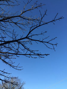
 The eighth bi-annual Race, Ethnicity and Place Conference (REP VIII) will be held September 21-23, 2016, at the Kent State Hotel, locally hosted by Kent State University.
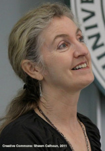
 This talk will explore what maps can do, or at least what these particular maps do, the ways these projects are counters to the rise of digital navigation and celebrations of what maps did in other eras, and how cartography lets us grasp or at least gaze at the inexhaustibility of every city, the innumerable ways it can be mapped. Session details forthcoming.